The Met Office has warned that a heatwave affecting Wales is developing into a "severe weather event" after issuing a second amber extreme heat warning within four days.
New Amber Warning for Much of Wales
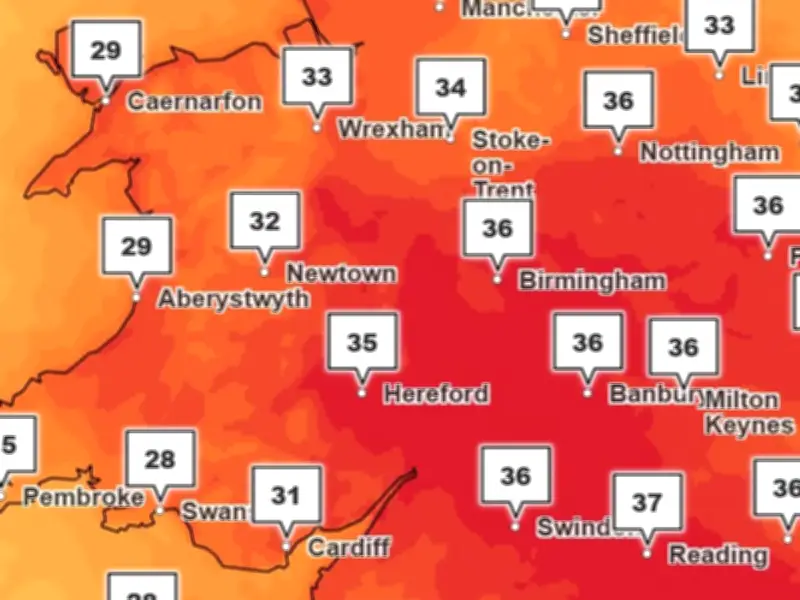
The new warning, covering much of Wales from midnight on Wednesday until 11.59pm on Thursday, comes as temperatures are forecast to exceed 30°C widely, with some areas potentially reaching 38°C.
The amber warning covers the following areas: Blaenau Gwent, Bridgend, Caerphilly, Cardiff, Carmarthenshire, Ceredigion, Conwy, Denbighshire, Flintshire, Gwynedd, the Isle of Anglesey, Merthyr Tydfil, Monmouthshire, Neath Port Talbot, Newport, Powys, Rhondda Cynon Taf, Swansea, Torfaen, the Vale of Glamorgan and Wrexham.

Potentially Dangerous Conditions
Forecasters said exceptionally high temperatures will be accompanied by humid conditions and unusually warm nights, with some areas expected to remain above 20°C overnight. BBC weather presenter Louise Lear described the conditions as "potentially dangerous".
The Met Office warned that the prolonged heat is likely to have impacts beyond those considered vulnerable to hot weather, with population-wide health effects possible.
Health and Infrastructure Risks
Its warning states there is a risk of serious illness and danger to life, while significant changes to daily routines and working practices may be required.
Disruption to transport networks is also possible, with delays and closures affecting roads, rail services and airports. Officials have also warned that heat-related failures of infrastructure could affect electricity, water, gas and mobile phone services.
Water Safety and Visitor Influx
The warning highlights an increased risk of water-related incidents as more people head to beaches, rivers and lakes during the hot weather.
Popular destinations across Wales, including Barry Island, Tenby, Llandudno, Rhyl, Aberystwyth, Barmouth and the Gower coast, are expected to see an increase in visitors.
Advice and Forecast Duration
People are being urged to stay hydrated, avoid strenuous activity during the hottest part of the day and check on older relatives, neighbours and those with underlying health conditions.
The Met Office said very hot conditions are likely to continue until at least Thursday, although there is a possibility that cooler air could begin moving in from the west later in the week.
A Met Office spokesperson said: "Very hot weather is likely to continue in general until at least Thursday across the highlighted region, although significant variations from place to place and day by day are likely. Temperatures by day are widely expected to exceed 30 Celsius, with the hottest areas potentially peaking around 38 Celsius.
"Overnight, temperatures are unlikely to fall much lower than high teens Celsius, and some places will not fall below 20 or 21 Celsius. These high temperatures will also be accompanied by high humidity.
"Cooler conditions may begin to become established from the west following this period, but confidence is low."