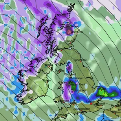
Britain is preparing for a potential weather onslaught later this month, with advanced forecasting models predicting a severe blizzard could blanket the country in as much as 31 inches (79cm) of snow within a 24-hour period. New snow maps have revealed the alarming scale of the incoming wintry blast, indicating that major cities across all four home nations will be impacted.
Snow Maps Pinpoint Blizzard's Path and Timing
According to detailed modelling from WXCharts and the ECMWF, the significant snow event is currently projected to begin at midday on Monday, January 26, 2026. The initial flurries are expected to target central and northern regions, with cities including Birmingham, Manchester, Edinburgh, and Glasgow all in line for accumulations.
The intense snowfall is forecast to continue through the night and into the following day, persisting until around midday on Tuesday, January 27. By 6am on the 27th, the snow is predicted to have spread to eastern areas, with parts of East Anglia seeing falls. Light snow is also a possibility for Northern Ireland at this time.
Southern England and London Face Late Onslaught
The weather models show a particularly concerning development for the south-east of England as the event progresses. By midday on January 27, the snow is expected to reach the capital and surrounding counties. The ECMWF model places London and Essex directly in the firing line, with snowfall potentially stretching from the south coast all the way up to the far north of Scotland.
Snow coverage maps for Wednesday, January 28, illustrate the full, widespread impact of this cold snap. At approximately 6am, settled snow is shown covering almost the entire UK. The only areas likely to escape a covering are Northern Ireland, parts of Wales, and the far south-west of England.
Potential Snow Depths and Official Warnings
Snow depth charts present a stark picture of the potential accumulations. The worst-hit area is expected to be the Scottish Highlands, which could see up to 79cm (31 inches) of settled snow. Northern England may face depths of around 34cm (13 inches), while the south-east, including London, could still receive a notable 7cm (3 inches).
The Met Office has indicated that conditions are likely to turn colder later in January, increasing the chance of snow across parts of the UK. In its forecast for January 19 to 28, the national weather agency stated: "Later in the period, there is an increased chance that conditions will turn colder. This aspect of the forecast is still somewhat uncertain but the potential transition to colder weather also increases the chance of snow across parts of the country."
This colder shift is expected to result from a battle between milder Atlantic systems and high pressure bringing colder air from the east. The BBC Weather forecast aligns with this outlook, suggesting "cold easterly flows" could develop by the end of next week, bringing the risk of "wintry showers" from the North Sea. However, forecasters caution that the milder Atlantic influence could still prevail, particularly in western regions.
Residents across the United Kingdom are advised to monitor the latest forecasts and travel updates closely, as this significant winter weather event could lead to widespread disruption to transport and services later this month.


