Researchers Claim Discovery of Noah's Ark Tunnels in Turkish Mountains
High in the remote mountains of eastern Turkey, a mysterious geological formation has captivated researchers who believe it could be the preserved remains of Noah's legendary Ark. According to the biblical account, this massive wooden vessel saved humanity and every species of animal from complete annihilation during a catastrophic global flood over 4,300 years ago. Now, a dedicated team of American investigators claims to have uncovered compelling new evidence supporting this extraordinary theory.
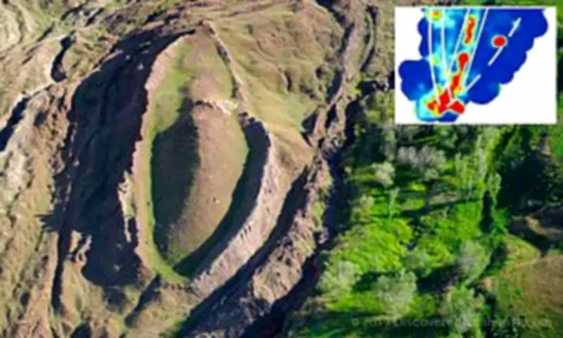
Ground-Penetrating Radar Reveals Hidden Structures
Andrew Jones, an independent researcher leading the Noah's Ark Scans project, has employed advanced ground-penetrating radar technology to map what he describes as a network of underground "corridors" converging on a hollow central chamber. Jones has designated this central space the "atrium," drawing direct parallels to the Bible's description of the Ark's internal layout. The sacred text specifies that the vessel contained three distinct levels constructed specifically to shelter Noah, his family, and pairs of animals from the deluge.
"God instructed Noah to bring the animals aboard," Jones explained in an interview with GB News. "These creatures would have remained there alongside Noah and his family. What's particularly fascinating is that these subterranean voids are not randomly scattered. They follow a deliberate, organized pattern. The ground-penetrating radar provides us with a unique method to peer beneath the soil using radar waves, revealing structures invisible from the surface."

Infrared Thermography and Soil Analysis
The research team has supplemented their radar findings with infrared thermography, a sophisticated heat-sensing technology capable of detecting hidden underground formations. This additional analysis has further suggested the presence of a distinct, ship-shaped hull buried deep within the earth at the site. Located approximately 18 miles south of Mount Ararat, Turkey's highest peak, the Durupınar Formation remained unknown to the modern world until relatively recently.
Historical records indicate that heavy seasonal rains and significant earthquakes in May 1948 eroded the surrounding mud, dramatically revealing the peculiar formation to a local Kurdish shepherd. The Bible states that Noah's Ark ultimately came to rest on the "mountains of Ararat" following a 150-day flood that submerged the entire Earth, eliminating every living creature not protected within the wooden sanctuary.
Intriguingly, the formation's proximity to a mountain with a peak that some observers believe mirrors the ark's purported shape and dimensions adds another layer to the mystery. Biblical measurements describe the ark as being 300 cubits long, 50 cubits wide, and 30 cubits high, which translates roughly to 515 feet in length, 86 feet in width, and 52 feet in height.
Scientific Debate and Compelling Evidence
The longstanding hypothesis that the ark landed on or near Mount Ararat has generated intense debate within scientific and archaeological circles. While many geologists maintain that the Durupınar Formation is a purely natural geological feature, the team at Noah's Ark Scans is convinced their findings point toward a man-made origin. In 2024, Jones disclosed that his team had identified angular structural features buried as deep as 20 feet below the surface, potentially representing rooms situated beneath a deck-like platform.
"This is not what you would anticipate finding if the site were merely a solid block of rock or the result of random mudflow debris," Jones told The Christian Broadcasting Network. "However, it is precisely what you would expect to discover if this were a constructed boat, consistent with the biblical specifications for Noah's Ark."
The researchers conducted extensive soil testing, collecting 88 samples from both inside and outside the perceived ship boundary in 2024. Laboratory analysis revealed abnormally high concentrations of potassium in the soil, a chemical signature consistent with the decomposition of vast quantities of lumber. The team noted that the extreme cold climate of the region, where the site remains completely frozen for nearly six months each year, may have contributed to the preservation and petrification of wooden components.

Distinctive Features and Future Investigations
Further observational evidence includes noticeable differences in vegetation. Jones reported that the grass growing within the boat-shaped formation exhibits a distinctly different color compared to the grass in the immediate surrounding area, a detail he suggests could indicate a man-made foundation altering soil composition. Another team member, William Crabtree, added that a discernible tunnel appears to run from the formation's tip toward its center, large enough for a person to walk through.
The team's ultimate ambition extends beyond current testing methods. "Our goal is not merely soil analysis or ground-penetrating radar scans, as valuable as those are," Jones stated in an interview with Patterns of Evidence. "We aim to physically access the interior of the structure. This could involve core drilling to obtain deep samples from where we detect the substructure and these voids, potentially allowing us to insert a camera. We are hopeful that such an opportunity may arise in the next research season. We will continue our work at the site for as long as the path remains open to us."