
Forecasters are warning that temperatures across Florida are set to plummet to levels lower than those currently being experienced in Iceland, as a powerful bomb cyclone continues to bring unprecedented winter conditions to the southeastern United States. The Sunshine State has been shrouded in uncharacteristic cold since Sunday, with snow flurries and frigid air replacing its typical mild climate.
Historic Freeze Warning Issued
The National Weather Service has issued a stark 'hard freeze' warning, effective from Sunday night through Monday morning. Residents across the state are being urged to prepare for overnight lows dipping into the upper teens, with daytime highs struggling to reach the 20s Fahrenheit. This represents a dramatic departure from the seasonal norms, where temperatures typically hover in the 70s during this period.
"Ensure you take actions to protect people, pipes, and plants," the NWS advised in its alert. "To prevent water pipes from freezing; wrap or drain or allow them to drip slowly." The service emphasised that these protective measures are critical given the severity of the forecasted conditions.

Regional Impacts and Record Lows
In the Tampa Bay area, the NWS confirmed that temperatures will drop below freezing once again for most locations. Northern and central portions of the region could experience hard freeze conditions with lows around 22 degrees Fahrenheit, accompanied by wind chills making it feel as cold as 17 degrees.
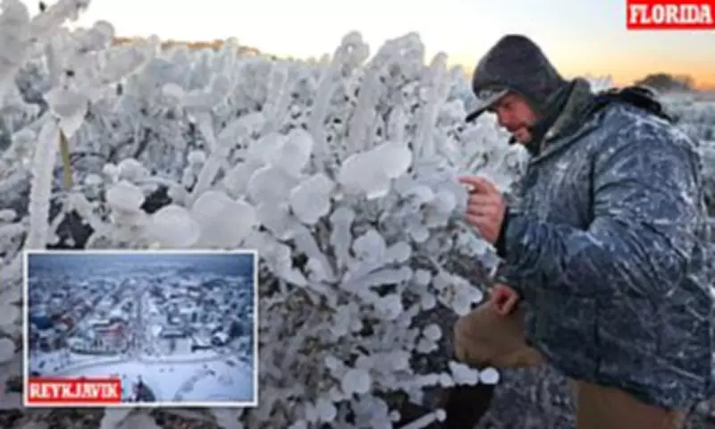
Orlando faces particularly dangerous conditions, with AccuWeather predicting a potentially record-breaking low of 25 degrees tonight. This would shatter the previous record of 32 degrees set back in 1980. Meanwhile, in Reykjavik, Iceland – a country synonymous with cold climates – temperatures are currently around 39 degrees, making Florida's forecast notably more severe.
The Bomb Cyclone Phenomenon
More than 150 million Americans are currently under cold weather warnings as this bomb cyclone, described by meteorologists as a 'winter hurricane', sweeps across the country. The storm system, named 'Winter Storm Gianna' by The Weather Channel, generates violent winds through rapid drops in air pressure.
States including the Carolinas, Virginia and Georgia have been worst affected, with snowfall reported as far south as Tampa, Florida. Central Florida could see temperatures drop into the high teens, creating potentially hazardous conditions for agriculture, infrastructure and daily life.
Expert Analysis and Further Warnings
Meteorologist Ryan Hall, known online as 'The Internet's Weather Man', warned that the bomb cyclone developing in the Atlantic this week will exhibit characteristics similar to a tropical cyclone. "That's pretty much a hurricane," Hall stated on Tuesday. "Whoever ends up on the western side of that in the cold area is going to get absolutely clobbered with snow."
Hall further cautioned that "another arctic blast is going to come around the backside of this low-pressure system, probably the most powerful one of the year so far, and it's going to plummet temperatures down 30 degrees below average."
Authorities have issued additional warnings about the accompanying wind advisory, urging residents to secure loose outdoor objects and exercise extreme caution when driving high-profile vehicles. Conditions on the water are also expected to become perilous for small boats and vessels.
Many affected areas are still recovering from last weekend's Winter Storm Fern, with some residents continuing to experience power outages. The consecutive severe weather events are testing emergency response systems and community resilience across the southeastern states.


