
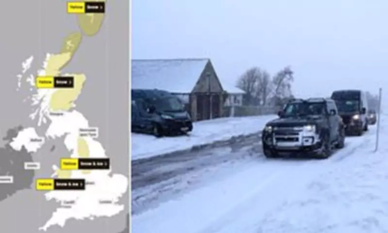
Significant parts of Britain are preparing for disruptive weather conditions as forecasters have issued multiple warnings for heavy snow, blizzards and freezing rain over the coming days. The Met Office has activated a series of alerts covering northern Scotland, northern England and North Wales, while nearly 250 areas remain under flood watch following recent severe weather systems.
Snow and Ice Warnings Across Northern Regions
The Met Office has implemented a substantial 39-hour yellow warning for snow across northern Scotland, active throughout today and until 3pm tomorrow. This alert predicts accumulations of up to 20cm (8 inches) in some areas, with particularly heavy snowfall expected above higher ground. A separate 15-hour snow and ice warning has been issued for parts of northern England and North Wales, valid from 6pm tonight until 9am tomorrow, with up to 3cm (1 inch) of snow anticipated.
Detailed Forecast for Scotland
In Scotland today, the snow warning extends north from Stirling and encompasses Perth, Aviemore, Inverness, Fife and the Highlands, reaching as far as the Orkney Islands. Forecasters indicate that rain in eastern and northern Scotland will increasingly turn to sleet and then snow as temperatures drop.

Expected accumulations vary significantly by elevation:
- Above 100m (330ft): 1-3cm (0.8-1.2 inches)
- Above 200m (650ft): Up to 10cm (4 inches) generally, with some locations potentially seeing 20cm (8 inches)
- Strong winds may create blizzard conditions and cause drifting of lying snow, particularly in northern warning areas
A separate warning for the Shetland Islands remains active until the end of today, predicting widespread accumulations of 1-3cm (0.8-1.2 inches) with up to 10cm (4 inches) on higher ground.
Northern England and Wales Alert
The yellow warning for snow and ice covering parts of northern England and North Wales spans multiple counties including County Durham, Derbyshire, Cumbria, Cheshire, Greater Manchester, Lancashire, Staffordshire and Yorkshire, along with Conwy, Denbighshire, Flintshire, Gwynedd and Powys in Wales.
The Met Office has warned of potential travel disruption on roads and railways, with additional risks of injuries from slips and falls on icy surfaces. Outbreaks of rain, sleet and snow will move north over mid and north Wales today, with snow accumulations mainly occurring above 200m (650ft), though 1cm is possible at lower elevations. There is also a chance of transient freezing rain over higher ground before conditions clear from the south through tomorrow morning.
Ongoing Flood Concerns in the South West
Meanwhile, the flood-hit South West remains under a rain warning until 9pm tonight, with up to 60mm (2.4 inches) of rainfall expected following major flooding caused by Storm Chandra. The Environment Agency currently has 76 flood warnings and 152 alerts active across England today, while Scotland maintains five warnings and Wales has six alerts plus one warning.
The Met Office has indicated in its rain alert that there is a small chance of fast flowing or deep floodwater causing danger to life in the South West. Additional concerns include potential power cuts and communities becoming cut off by flooded roads. Accumulations of 10-20mm (0.4-0.8 inches) are expected fairly widely, with up to 40-60mm (1.6-2.4 inches) predicted over Dartmoor on already saturated ground.
This warning covers areas of Cornwall, Devon, Dorset, Hampshire, Somerset and Wiltshire, regions still recovering from Storm Chandra's impact on January 26th when several sites recorded their highest ever daily rainfall for January. A major incident was declared in Somerset where approximately 50 properties experienced flooding from the storm.
Temperature Drop and Travel Disruption
Temperatures are set to drop to freezing in places tonight, with wind chill making conditions feel as cold as -5°C (23°F) in Scotland and -2°C (28°F) in England this afternoon. The cold snap follows a series of low-pressure weather systems that have moved across the UK from the Atlantic throughout last month, bringing repeated outbreaks of wet and windy conditions.

Three named storms - Goretti, Ingrid and Chandra - have all delivered significant downpours to many areas, particularly affecting the South West with flooding and widespread travel delays. The Met Office has noted that an exceptional amount of rain made last month the second wettest January ever recorded in Northern Ireland and the sixth wettest in southern England.
Transport Impacts
Transport operators are already preparing for disruption. Ferry operator CalMac has announced several yellow and amber warnings for service disruptions and cancellations across many routes. Scotrail has encouraged travellers to check journey statuses ahead of time, stating they plan to run a full service but some disruption is possible.
The Scottish Environment Protection Agency (SEPA) maintains one flood warning for the Churchill Barriers area of the Orkney Islands, while authorities across affected regions continue to monitor conditions closely as this latest weather system develops.


