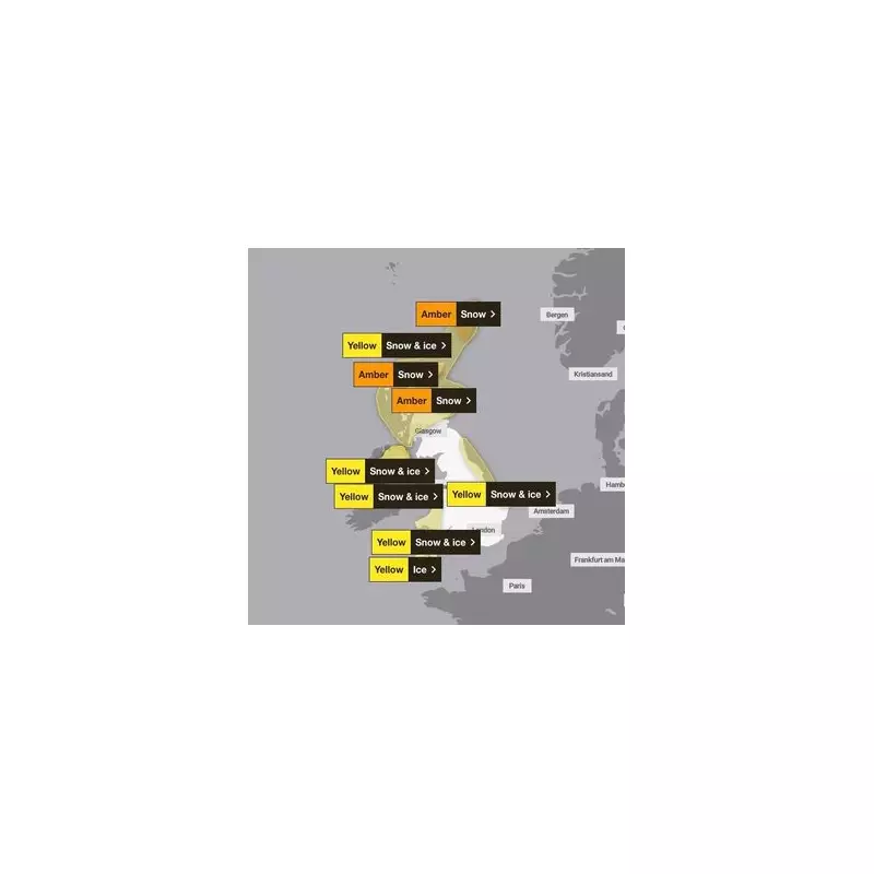
The United Kingdom is braced for a severe and prolonged spell of Arctic weather, with the Met Office activating a raft of snow and ice warnings across the nation. Forecasters have mapped out seven separate alerts for Saturday, 3rd January 2026, including a significant amber warning for parts of Scotland anticipating substantial accumulations.
Arctic Blast Brings Bitter Cold and Snow Showers
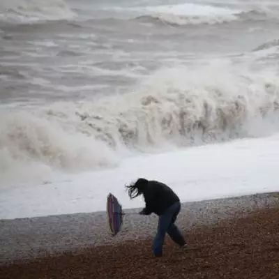
The Met Office has confirmed that a surge of Arctic maritime air is responsible for the dramatic temperature drop, creating a bitterly cold feel and triggering frequent snow showers, particularly in northern regions. Temperatures on Friday plunged to -5.7°C in Drumnadrochit in the Scottish Highlands, and similarly frigid conditions are expected to become more widespread.
Meteorologist Annie Shuttleworth warned of the ongoing risks. "We've got Arctic maritime air moving in from the north, bringing a bitterly cold feel, and some frequent snow showers to northern areas," she stated. The forecaster highlighted a specific weather feature affecting eastern zones, raising the threat of snow for northeast England.

Substantial Snow Accumulation and Blizzard Risk
The most severe warning is an amber alert for snow, valid until midday on Saturday. It covers extensive areas of Scotland, including the Highlands, Grampian, Tayside, and the Orkney & Shetland islands. Within this zone, some locations could see snow accumulations of up to 20 inches (50cm) on the highest ground by the end of the weekend.
Ms Shuttleworth added a concerning note about accompanying winds: "There's an added risk of strong winds that brings a risk of blizzards and snow drifting." This combination significantly heightens the potential for travel disruption and hazardous conditions.
Icy conditions are also a major hazard. "We could see some ice developing where we do see any of those snow showers throughout the course of Saturday," Shuttleworth explained, noting that Saturday night will be "another widely very cold night," with temperatures potentially falling as low as -8°C in northern areas with lying snow.
Nationwide Warnings and Expected Disruption
Beyond the amber alert, a complex mosaic of yellow warnings for snow and ice is in force. These cover:
- Northern Scotland, Strathclyde, and the Isles: A yellow warning for snow and ice until midday.
- Northern Ireland: Two separate yellow warnings for snow and ice, one until midday and another stretching from midday Saturday until midday Monday.
- Northeast England and Yorkshire: A yellow warning for snow and ice valid until Sunday, encompassing Durham, Northumberland, and North Yorkshire.
- East Midlands and East of England: Lincolnshire and Norfolk are under a yellow warning until Sunday.
- Wales: A yellow warning for snow and ice for most of the country until 10:00 am Saturday.
- South West England: Cornwall, Devon, and Somerset have a yellow warning for ice until 10:00 am.
The Met Office and travel authorities are advising the public to expect disruptions, especially in Northeast England. Icy patches on untreated roads and pavements, coupled with blowing snow, will make journeys hazardous. Coastal areas along the North Sea, such as Tyne and Wear and County Durham, are also forecast to experience strong winds.
This cold snap marks a severe start to 2026, with the Met Office emphasising the prolonged nature of this icy spell. Residents are urged to stay updated on the latest forecasts and warnings, plan essential travel carefully, and take necessary precautions against the cold.