
An extraordinary satellite photograph released by NASA has laid bare the immense scale of the winter storm that gripped New York City at the end of January, a period of bitterly cold weather that tragically resulted in the deaths of at least ten people. The image, captured from space, provides a stark and powerful visual testament to the deep freeze that enveloped the region.
A Chilling View from Orbit
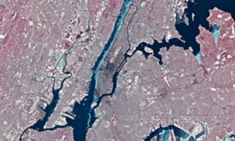
On January 28th, as temperatures struggled to reach a high of just 23°F (–5°C), the Landsat 8 satellite obtained a remarkable overhead view of New York City and neighbouring New Jersey. The photograph clearly shows extensive portions of the iconic Hudson River, the East River, and the Jacqueline Kennedy Onassis Reservoir frozen solid, transformed into vast sheets of ice.
NASA scientists explained the phenomenon, noting: "Much of the ice in the image likely floated there from farther upriver, where tidal currents are weaker and salinity is lower. These conditions allow water to freeze sooner and at higher temperatures than the faster-flowing, brackish water near the river's mouth." While experts suggest a complete freeze of the Hudson around Manhattan is improbable today, such an event was recorded historically in 1888.

The Technology Behind the Image
The Landsat 8 satellite, launched in 2013, is a crucial tool for NASA, providing high-quality imagery of Earth's surface. During its pass over New York City around midday on January 28, it snapped this incredible false-colour photo. In this specialised view, ice appears in a distinct light blue hue, while vegetation is rendered in red, creating a clear contrast between the frozen waterways and the urban landscape.
Real-World Impacts of the Freeze
The severe ice conditions had immediate and disruptive consequences. With large swathes of the Hudson River frozen, the NYC Ferry service was compelled to suspend operations for several days, disrupting commuter travel. However, NASA highlights that iced-up rivers pose broader risks beyond transportation.
The space agency outlined several critical implications:
- Increased potential for flooding and damage to infrastructure.
- Significant alterations to hydrologic processes.
- Negative effects on water quality and aquatic habitats.
In response to these challenges, NASA noted that scientists, government agencies, and emergency responders are increasingly utilising advanced remote sensing technologies. These include synthetic aperture radar and hyperspectral imaging to meticulously track river ice. Improved monitoring capabilities are vital for enhancing water resource management and mitigating the damaging effects of ice on both infrastructure and local ecosystems.
Further Signs of a Deep Winter
Beyond the dramatic river ice, the satellite image reveals other unmistakable signs of the intense winter chill. A fresh blanket of snow coats the ground, and the low angle of the midwinter sun causes the skyscrapers of Midtown and Lower Manhattan to cast exceptionally long, dramatic shadows across the frozen city.
Adding a touch of local folklore to the meteorological event, NASA referenced Staten Island's famous weather-prognosticating groundhog, Staten Island Chuck. On February 2nd, the rodent emerged, and according to tradition, his sighting signals six more weeks of winter. Interestingly, when compared with data from NOAA's National Centers for Environmental Information, Chuck has been deemed the most accurate of his peer weather "forecasters."
NASA remarked: "This year, Chuck might be right, at least in the near term: the National Weather Service forecast called for below-average temperatures to persist, with Arctic air returning to the city by the weekend." This satellite image serves as a powerful, sobering record of a severe weather event whose impacts were felt from the city's streets to its very rivers.


