
UK Braces for Widespread Blizzard as 75 Counties Face Snow Alert
Weather forecasters have issued a stark warning, with maps indicating that a colossal blizzard stretching over 610 miles could strike 75 counties across the United Kingdom in the coming days. This significant weather event is predicted to bring freezing conditions and substantial snowfall, with some regions potentially seeing accumulations of up to 13 inches.
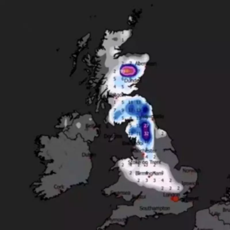
Extensive Snowfall Predicted for February 13
According to detailed analysis from WXCharts, the blizzard is set to make landfall on February 13, creating a miserable start to the month for many Britons. The snow wall is expected to extend from the northernmost parts of Scotland all the way down to southern England, impacting counties such as Suffolk and even reaching Greater London. This widespread snowfall could disrupt travel and daily life on a large scale.
The heaviest snow is forecast to blanket North Yorkshire and its surrounding areas, where weather maps show deep purple markings indicating intense precipitation. A total of 75 counties will be affected throughout the day, with the possibility of further snowfall in the subsequent days, as reported by The Express.

Affected Regions Across the UK
The counties anticipated to experience snow on Friday, February 13, include a broad swathe of the nation:
- England: Northumberland, Cumbria, Tyne and Wear, Durham, North Yorkshire, Lancashire, East Riding of Yorkshire, West Yorkshire, South Yorkshire, Greater Manchester, Merseyside, Lincolnshire, Nottinghamshire, Derbyshire, Staffordshire, Shropshire, West Midlands, Herefordshire, Worcestershire, Gloucestershire, Bristol, Warwickshire, Leicestershire, Rutland, Cambridgeshire, Norfolk, Suffolk, Northamptonshire, Oxfordshire, Buckinghamshire, Bedfordshire, Greater London, Hertfordshire, Essex.
- Wales: Conwy, Gwynedd, Denbighshire, Wrexham, Flintshire, Powys, Ceredigion.
- Scotland: Aberdeenshire, Angus, Ayrshire, Banffshire, Berwickshire, Buteshire, Caithness, Clackmannanshire, Dumfriesshire, Dunbartonshire, East Lothian, Fife, Inverness-shire, Kincardineshire, Kinross-shire, Kirkcudbrightshire, Lanarkshire, Midlothian, Moray, Nairnshire, Orkney, Peeblesshire, Perthshire, Renfrewshire, Ross and Cromarty, Roxburghshire, Selkirkshire, Shetland, Stirlingshire, Sutherland, West Lothian, Wigtownshire.
- Northern Ireland: Derry and Antrim are expected to see some light snowfall according to the latest maps.
Met Office Long-Range Forecast Supports Snow Predictions
While snow forecasting can be challenging, the Met Office's long-range weather forecast for February 11 to 20 aligns with these predictions, suggesting that parts of the nation could experience flurries. The weather agency stated: "Predominantly cyclonic patterns are expected to dominate the UK. The early part of this period could see colder conditions becoming established more widely for a time, bringing with it the likelihood of some snow."
The Met Office added that milder and wetter weather might persist in the far south, but by the end of this period, Atlantic depressions could shift northward, maintaining unsettled conditions with further rain and strong winds. Many areas may become milder due to westerly influences, though colder conditions could linger in the northeast.
No Immediate End to Gloomy Weather Patterns
Britons have been greeted by persistent rain and showers throughout February, with the Met Office offering a bleak outlook on when this wet spell will conclude. Met Office operational meteorologist Dan Stroud commented: "Unfortunately, there's no end in sight." He explained that a large area of high pressure to the north and east is blocking low-pressure systems, preventing any significant change in the forecast. Additionally, the jet stream positioned far south is contributing to exceptional wet weather in Spain and Portugal, indirectly affecting UK conditions.
This impending blizzard underscores the volatile nature of British weather, urging residents in the affected counties to prepare for potential disruptions and hazardous travel conditions as the snow event approaches.


