
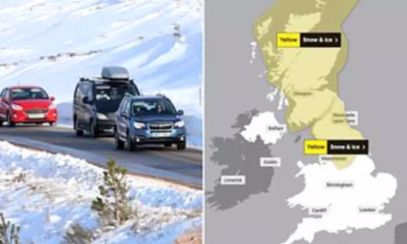
Arctic Blast Brings Snow and Ice Across the UK
Britons are preparing for a severe Arctic blast that is set to deliver up to four inches of snow, icy conditions, and temperatures plummeting to minus 7 degrees Celsius. The Met Office has issued two yellow weather warnings for wintry conditions, covering parts of Scotland and northern England until midday today. These warnings highlight the risk of travel disruption due to snow showers and icy roads.
Health Alerts and Weather Patterns
In response to the forecast, the UK Health Security Agency has activated yellow cold health alerts for northern England and the Midlands, effective from 6am this morning until 8am on Monday. The agency warns that the cold snap could have minor impacts on health and social care services, including increased demand for healthcare and heightened risks for vulnerable individuals.
This Arctic maritime air mass is pushing colder conditions southwards from northern Scotland, with outbreaks of rain expected early this morning. The shift follows an exceptionally wet start to the year, characterized by overflowing rivers, hundreds of flooded properties, and continuous rainfall in some regions. Over 75 areas across the country remain under flood warnings as downpours persist, with no prolonged dry spell anticipated for at least a week.

Forecast Details and Travel Advisories
Tomorrow is predicted to be the driest day in recent times, with sunshine expected across the entire UK. However, today will see cloudy skies and rainfall in the south, clearing later. Temperatures will stay below average throughout the weekend, according to the Met Office. A spokesperson for National Rail has advised travelers to check services before departing, as snow and ice may affect rail journeys.
Forecaster Marco Petagna explained, "We've got colder air starting to feed in from the north, gradually pushing south across all parts over the next 24 hours. As the air sinks, we'll see outbreaks of rain, with some snow mainly on hills, though across parts of Scotland, it's at quite low levels." He urged caution regarding ice and snow, noting potential transport disruptions.
Petagna added that Friday night will likely bring widespread frost, but Saturday should offer "the best day we've seen for some time" with ample sunshine across the UK. While temperatures will be cooler than average, the sunshine may provide some relief.
Record Rainfall and Ongoing Challenges
The Arctic blast arrives after a record-breaking month of rain, with January becoming the wettest on record for Cornwall in southwest England and County Down in Northern Ireland. The Met Office reported that many have felt winter is "stuck on repeat," as 26 weather stations set new records for January rainfall.
To date, the UK has experienced 89% of the average rainfall expected for meteorological winter (December, January, and February), while England has exceeded it by 11%. Regions such as Devon, Cornwall, Worcestershire, Somerset, and West Sussex have recorded over 30 consecutive days of rain, with locations like North Wyke in Devon, Cardinham in Cornwall, and Astwood Bank in Worcestershire seeing rain every day of the year so far.


