
Widespread Snowstorm Set to Blanket the UK with Heavy Accumulations
New meteorological data suggests that a significant snow event is poised to impact the vast majority of the United Kingdom, with forecasts predicting a 24-hour blizzard that could deposit up to 16 inches of snow in certain areas. According to detailed maps from WXCharts, the snowfall is expected to commence from midnight on February 14, affecting approximately 90% of the country.
Regional Snowfall Predictions and Exceptions
The WXCharts projections indicate that most regions across the UK will experience snow accumulation, with exceptions limited to specific coastal and southern areas. Notably, small pockets on the east coast, including parts of the East Midlands and East Anglia, as well as Cornwall and sections of Dorset, Wiltshire, and Somerset, are anticipated to see minimal to no snowfall. For the majority of affected zones, around two inches of snow is forecasted, but heavier accumulations are predicted in elevated regions such as the Peak District, Yorkshire Dales, and particularly the Cairngorms.
Contrasting maps for the same period reveal a more concentrated snowfall pattern, with the Cairngorms potentially receiving up to 16cm (approximately 6.3 inches) and the Yorkshire Dales seeing accumulations of up to 6cm. This variability highlights the uncertainty in precise snowfall distribution, but underscores the potential for significant disruption in northern and high-altitude areas.

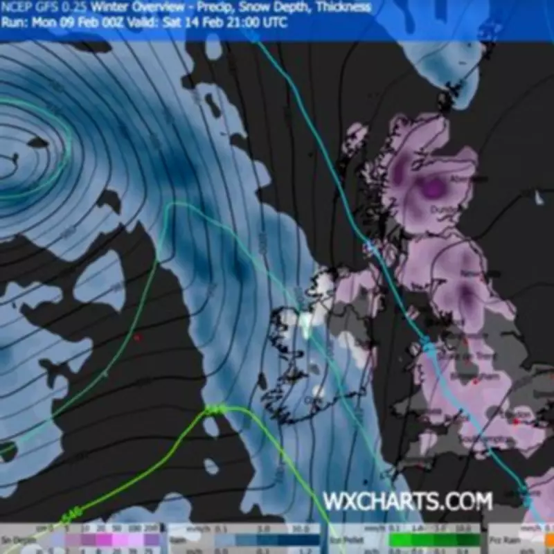
Extended Snowfall and Meteorological Context
The snowfall is not expected to be a brief event; further precipitation is forecasted throughout the day on February 14 and into the evening, around 9pm. During this extended period, most of the country is predicted to receive around 2cm of snow, with exceptions including areas in Buckinghamshire and Oxfordshire, the East Midlands, East Yorkshire, East Anglia, western Wales, Cornwall, Sussex, the West Midlands, Manchester, and the northwest.
The Met Office has provided additional context through its long-range weather forecast for February 13 to February 22. The agency notes that "predominantly cyclonic patterns are expected to dominate the UK," with colder conditions likely to establish more widely early in the period. This could bring snow, primarily to the north and northeast, offering a temporary respite from wet weather in the south. However, by the end of the period, Atlantic depressions may shift northward, maintaining unsettled conditions with rain and strong winds, though milder westerly influences could prevail in many parts, with colder conditions possibly lingering in the northeast.
Current Weather Warnings and Impacts
In the immediate term, parts of Scotland are already facing weather challenges, with persistent and heavy rain forecasted for Tuesday and Wednesday. The Met Office has issued a yellow weather warning for a stretch covering Perth, Dundee, and up to Aberdeenshire, in effect from 9am on Tuesday through Wednesday night. This rain, falling on already saturated ground, raises concerns about disruption and potential flooding.
A Met Office spokesman elaborated: "Persistent, and at times heavy, rain will fall onto already saturated ground over eastern Scotland, which may cause further disruption and localised flooding. 15-30mm of rain is likely to fall quite widely with 40-60mm possible in places over higher ground." Additionally, snow is expected on some higher roads in Aberdeenshire by the end of Tuesday, compounding travel difficulties. Drivers have been warned to anticipate challenging conditions and possible road closures in the region.
As the UK prepares for this potential snow blitz, residents are advised to stay updated with the latest forecasts from the Met Office and WXCharts, and to take necessary precautions for travel and safety during the anticipated severe weather.


