The United Kingdom is preparing for a brutal and prolonged Arctic onslaught, with weather models predicting a week of dangerously low temperatures and significant snowfall. A severe cold snap is forecast to grip the nation from early January, bringing the threat of temperatures as low as -14°C and snow accumulations of over 40 centimetres in some regions.
Week-Long Deep Freeze Set to Grip the Nation
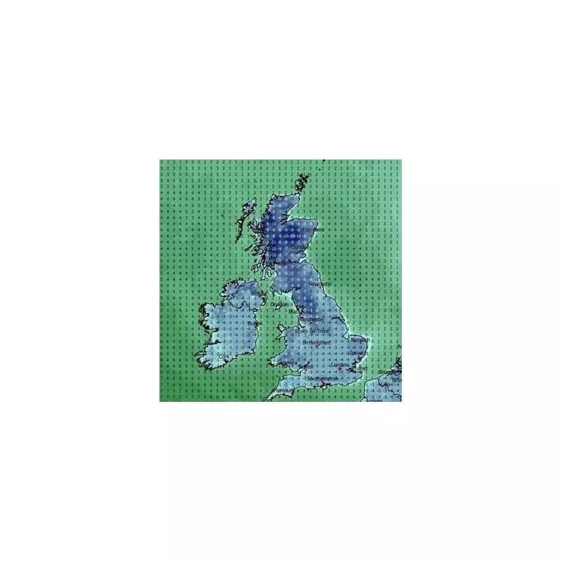
According to the latest data from WX Charts, the icy conditions are expected to take hold from Saturday, January 4, and persist until Friday, January 10. The entire country will experience a sustained period of sub-zero chills, with daytime highs struggling to get above freezing for most. The cold air, already moving southwards, signals a need for the public to wrap up warm as the New Year begins.
The situation will be exacerbated by low-pressure systems arriving from the west, which will clash with the frigid air mass. This collision is predicted to generate widespread snow, with forecasts indicating that the white stuff will cover the UK from top to bottom, reaching the south coast by Monday, January 6.

Day-by-Day Forecast: Extreme Cold and Snow Accumulation
Saturday, January 4: The deep freeze begins in earnest. Daytime temperatures will hover between just 1°C and 3°C for most, before plummeting overnight. Northern Scotland could see lows of -10°C, with much of the UK experiencing a widespread frost at -4°C.
Sunday, January 5: The cold intensifies. By midday, only parts of southern England may creep above 0°C. By 6 pm, the entire nation will be in the freezer, with widespread overnight lows of -6°C to -8°C. The worst of the cold will hit Scotland, where areas near Aberdeen could plunge to a bone-chilling -14°C.
Monday, January 6: This is expected to be one of the coldest nights. By early evening, temperatures will fall below -5°C across much of the UK. Eastern England, including parts of Norfolk, could see -7°C.
Tuesday, January 7: Hazardous travel conditions are likely due to widespread frost and ice. Daytime temperatures may see a slight rise to around 5°C in central England, but Scotland braces for another severe night with lows of -12°C.
Wednesday, January 8: This day brings the highest risk of heavy snow. Western Scotland could see accumulations of up to 43cm, with northern England potentially receiving 17cm. Daytime highs will be just 2°C or 3°C in England, while Scotland remains locked in deep freeze with highs of -7°C.
Thursday, January 9 & Friday, January 10: The cold air maintains its grip, though a slight easing is possible by Friday. However, nights will remain severely frosty, continuing the risk of ice-related disruption.
Official Warnings and Long-Range Outlook
The Met Office has indicated that Arctic winds will drive the extreme conditions, bringing snow showers to areas exposed to onshore winds. They warn of "significant accumulations" where these showers occur. There is also a risk of more organised bands of sleet and snow moving southwards, affecting inland areas.
While confidence decreases for the second week of January, the Met Office states that the cold conditions may persist, leading to an ongoing risk of winter hazards across the UK. The public is advised to stay updated with the latest forecasts and warnings, and to prepare for significant travel disruption, hazardous icy surfaces, and a need for extra heating during this severe Arctic blast.