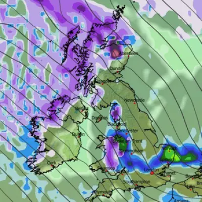
The UK is set for a sharp temperature drop this week as a blast of cold Arctic air sweeps across the country, bringing with it the risk of snow, ice, and widespread frost. The Met Office has activated multiple yellow weather warnings, highlighting the potential for hazardous conditions.
Warnings and Widespread Impacts
From Monday through to Thursday, yellow warnings for snow and ice are in force for parts of Scotland and northern England. This marks the first significant cold snap of the winter season, with sub-zero temperatures expected. Met Office meteorologist Alex Burkill explained that this frigid air is originating from Siberia and moving across the Arctic Ocean towards the UK.
Tuesday is expected to see wet weather across Scotland, Northern Ireland, and northern and western parts of England and Wales. "With that cold air we have across us, no wonder we are going to see some sleet and snow mixed in with that as well," Mr Burkill stated. Icy patches are anticipated nationwide, potentially creating "difficult, slippery conditions" for travellers.
A Marked Drop in Temperature
The overall weather for the next seven days is forecast to be "markedly colder" than the conditions experienced last week. While temperatures on Tuesday will be "closer to normal" in the south, they are already "below average for this time of year" in the north.
The cold will intensify as the week progresses. By Wednesday, temperatures across most of the UK, including the south, will have fallen by "a couple of degrees," turning colder than the seasonal average. "Watch out for some brisk winds, particularly towards the west, could be close to gales through both Wednesday and Thursday," Mr Burkill cautioned, noting that the wind will amplify the cold feel.
Snow Disruption and a Harsh Frost
The forecast indicates a continued risk of wintry showers. On Thursday, northern areas are more likely to see sleet and snow, with showers also affecting western parts. Scotland and eastern northern England in particular can expect snow, which may lead to "some disruption."
The cold will peak on Thursday night into Friday, which is predicted to be a "particularly chilly night" with a "widespread harsh frost." While rain will later sweep into western areas from Northern Ireland over the weekend, it will be accompanied by milder air, causing temperatures to finally rise.


