
UK Snow Maps Reveal 600-Mile Blizzard Will Impact Millions of Brits Within Days
Advanced weather modelling maps indicate that the United Kingdom will be hit by a significant snow event in less than two weeks, with blizzard conditions expected to impact cities across the entire length of the country. The latest forecasts suggest that millions of residents could face disruption as a result of this impending winter storm.
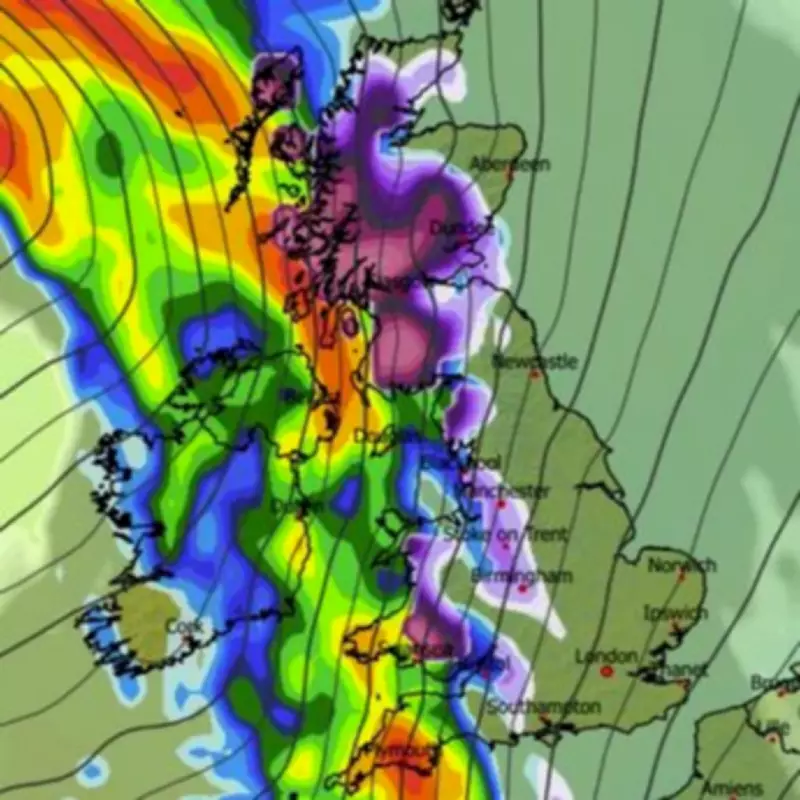
Widespread Snowfall Predicted for Mid-February
The GFS weather model suggests that Scotland, England, Wales, and Northern Ireland could all experience snowfall on February 15, with heavy rain also anticipated in many areas. Precipitation maps indicate that frontal systems approaching from the Atlantic will bring snow across western regions during the morning hours before moving further east by midday.
Later in the afternoon, strong winds and icy conditions are expected to spread snow to eastern and central regions as well. Several major population centres appear to be in the firing line, including London, Manchester, Birmingham, Cardiff, Edinburgh, and Glasgow.

Met Office Forecasts Cyclonic Patterns
In its long-range forecast covering February 8 to February 17, the Met Office has indicated that cyclonic patterns will dominate across the country. These large-scale, rotating weather systems are known to create stormy conditions and intense winds that can significantly impact travel and daily life.
The national weather service states: "Frontal systems over the Atlantic are likely to approach the UK at times, tending to become slow moving as they encounter a blocking area of high pressure to the northeast. This will result in showers or longer spells of rain spreading across the UK, these heavy at times."
Snow Depth and Coverage Predictions
Snow coverage maps reveal that only the south-west region and Northern Ireland are likely to avoid significant snowfall, with snow expected to settle on the ground across approximately 600 miles of the UK. Snow depth charts suggest that accumulation could reach as much as 41 centimetres in parts of Scotland, with around 4 centimetres predicted for northern England and certain areas of Wales.
The Met Office has further explained: "As these bands of rain spread northwards, snow is possible across northern England and Scotland, mainly over high ground. Strong winds could develop in places, especially along coastal areas. Temperatures will probably be close to normal overall, with any cold conditions more likely in the north."
Current Weather Conditions and Warnings
Currently, the Met Office forecasts cloudy conditions with some sunny spells across southern counties, while southern England is expected to remain dry. Northern England and Northern Ireland are experiencing rain that will spread southward as winds intensify throughout the evening.
Scotland is already seeing snow on higher ground and rain in some areas, with a yellow warning for snow in force across northern and eastern regions. Accumulations of 1 to 3 centimetres are expected above 100 metres by Wednesday, with up to 20 centimetres possible in some locations above 200 metres.
A second yellow warning has been issued for the Shetland Islands, effective from 6pm today until the end of Wednesday. Wintry showers are predicted to turn into more persistent snowfall from Tuesday evening, continuing throughout Wednesday with totals of 1 to 3 centimetres widely expected and up to 10 centimetres possible over higher ground.
Potential Disruption and Travel Impacts
The combination of sleet and snow could bring considerable disruption today and tomorrow, with road, bus, and train services likely to experience delays. Rainfall amounts are expected to be highest in western parts of the UK, including areas already sensitive to flooding, which could compound the challenges presented by the winter weather.
Residents across the country are advised to stay updated with the latest weather forecasts and travel information as the situation develops over the coming days.


