
Britain is on high alert as a severe weather system threatens to unleash chaos across the nation, with both the Environment Agency and the Met Office issuing urgent warnings for extensive flooding and treacherous icy conditions. Forecasters are advising the public to brace for a dangerous 48-hour period where heavy rain transitions into a deep freeze, creating hazardous travel conditions and potential property damage.
Flood Warnings Dominate the Landscape
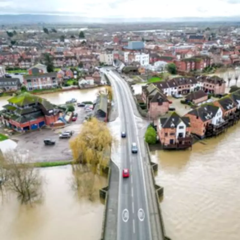
The Environment Agency has escalated its response by releasing hundreds of flood warnings and alerts across England. On Monday afternoon, officials confirmed 73 flood warnings, indicating that flooding is expected, alongside 196 flood alerts where flooding is possible. These notices are split into red and amber categories, with red warnings urging residents to "act now" in approximately 70 areas, while nearly 200 amber warnings advise people to "take care" as the situation develops.
Jonathan Day, the flood duty manager at the Environment Agency, provided a sobering update, noting that while more than 24,000 homes and businesses have been protected by flood defences, around 330 properties have already been inundated. The agency attributes the heightened risk to a prolonged spell of heavy rain that has saturated the ground, leaving many regions vulnerable to rapid flooding over the next 24 hours.

Icy Conditions Compound the Crisis
As if the flooding were not enough, the Met Office has concurrently issued yellow warnings for snow and ice, covering vast swathes of the country. From 3pm on Monday, a warning for sleet and snow took effect across much of Scotland, cautioning that icy surfaces could disrupt train journeys and make roads perilous. Shortly thereafter, at 6pm, an ice alert was activated, stretching from Edinburgh to Ipswich and encompassing major cities such as Newcastle, Leeds, Sheffield, Lincoln, Nottingham, and Norwich.
Northern Ireland was not spared, with a similar ice warning coming into force two hours later. All three alerts are scheduled to remain active until 10am on Tuesday, underscoring the widespread nature of the threat. Met Office meteorologist Liam Eslick highlighted the risks, warning that overnight temperatures are set to plummet, leading to frosty and icy stretches, particularly in Northern Ireland, northern England, and Scotland.
Forecast Details and Public Advice
Liam Eslick elaborated on the meteorological conditions, explaining that while southern regions might experience relatively mild temperatures of around 9 or 10 degrees Celsius, northern areas, especially Scotland, will face northerly winds that could turn showers into snow, even at lower levels. He emphasised that as evening falls, clearer skies will cause temperatures to drop sharply, creating icy patches that pose a significant hazard for Tuesday morning commuters.
"We are expecting those temperatures to fall away and develop some frosty and icy stretches, especially across Northern Ireland, northern England, and Scotland, so do take care first thing in the morning on Tuesday," Eslick stated. He added that although southern areas might stay above freezing temporarily, rural spots could see frost, while northern regions will likely experience freezing conditions, leading to a "bright and crisp Tuesday morning" but with lingering dangers.
Implications for Travel and Safety
The dual threats of flooding and ice have raised serious concerns for public safety and infrastructure. Authorities are urging residents in affected areas to avoid unnecessary travel, prepare for potential power outages, and stay informed through official updates. The combination of saturated ground from ongoing rain and sudden freezing temperatures increases the risk of black ice on roads and pavements, making pedestrian and vehicular movement hazardous.
This weather event serves as a stark reminder of the UK's vulnerability to extreme seasonal shifts, with experts linking such patterns to broader climate trends. As the nation navigates this challenging period, the focus remains on mitigation and preparedness, with both the Environment Agency and Met Office continuing to monitor developments closely and issue further guidance as needed.


