
If you've felt like your umbrella has become a permanent accessory over recent weeks, you're certainly not alone. The Met Office has officially confirmed that last month ranked among the wettest Januarys ever recorded in Britain, with rainfall levels soaring 17 per cent above the long-term meteorological average.
A Persistent Atlantic Weather Pattern
This exceptionally wet and windy weather was driven by a relentless series of Atlantic low-pressure systems that swept repeatedly across the UK. Met Office science manager Dr Amy Doherty explained the phenomenon in detail.
'January has been exceptionally wet because we've seen a very persistent Atlantic weather pattern,' Dr Doherty stated. 'A strong jet stream has repeatedly steered low-pressure systems towards the UK, bringing frequent spells of rain and wind.'

She further noted that with minimal opportunities for drier interludes, the ground became thoroughly saturated. This meant that even moderate rainfall events had a significantly amplified impact on flooding and surface water.
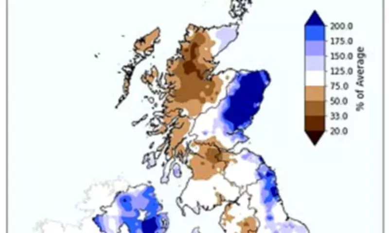
Regional Variations and Record-Breaking Totals
The rainfall was not evenly distributed across the nation, revealing stark regional contrasts. Northern Ireland was particularly drenched, experiencing its wettest January in 149 years – and its second wettest on record overall. The country saw a staggering 70 per cent more rain than its average.
England as a whole recorded 50 per cent more rainfall than usual, but this masked a dramatic north-south divide within the country. Southern England was battered with 74 per cent more rain than average, while Northern England recorded a comparatively modest 10 per cent increase.
In a contrasting trend, Scotland actually reported below-average rainfall for the month. At the county level, several areas saw historic deluges. Cornwall and County Down experienced their absolute wettest January on record. Meanwhile, County Londonderry, Dorset, Kincardineshire, Angus, Hampshire, Devon, and Surrey all recorded their second wettest January since records began in 1836.
Peak Rainfall Events and a Chilly Month
The most notable day for rainfall was 26 January, when Storm Chandra swept across Britain. On this single day, Katesbridge in County Down recorded a staggering 100.8mm of rain – almost tripling the previous site record of 38.2 mm set in 2005.
Other locations also saw daily records tumble. Dunkeswell Aerodrome in Devon recorded 52.8mm, while Hurn in Dorset, Cardinham in Cornwall, and Plymouth Mountbatten in Devon all exceeded their previous daily rainfall records.
As well as being exceptionally wet, January was also a notably cold month. Although temperatures climbed during the latter half of the month, the UK's average temperature for January finished at 0.5°C below the long-term average.
The Broader Climate Context
This news of a sodden and chilly January arrives shortly after the Met Office confirmed that 2025 was Britain's hottest year on record. The average UK temperature last year reached a balmy 10.09°C, which is 0.96°C above the long-term average. 2025 now joins 2022 and 2023 in the top three warmest years since records began in 1884.
According to the Met Office, this trend serves as a clear demonstration of the impacts of climate change. Dr Mark McCarthy, head of climate attribution at the Met Office, provided expert analysis on the shifting climate patterns.
'We're increasingly seeing UK temperatures break new ground in our changing climate, as demonstrated by a new highest UK mean temperature record just three years after the last record,' Dr McCarthy said. 'This very warm year is in line with expected consequences of human-induced climate change.'
He emphasised that while not every year will be the warmest on record, the observational data and climate models provide clear evidence that human-induced global warming is actively impacting the UK's climate system, contributing to both extreme warmth and periods of intense rainfall.


