Britons are being warned to prepare for an extremely hazardous weather phenomenon later this week, as a severe Arctic blast continues to grip the nation with sub-zero temperatures and widespread snow.
From Snow to a Glaze of Ice
The country has experienced a harsh early taste of winter this week, with weather warnings active across the UK. The Met Office has reported temperatures plunging as low as -12C in parts of Scotland, with significant travel disruption already occurring.
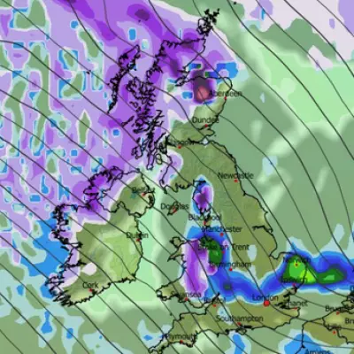
Now, forecasters are tracking the development of a more rare and dangerous threat: freezing rain. Weather maps from the GFS model indicate patches of this perilous precipitation, shown in orange, will develop over northern Scotland around 6pm on Friday.
Why Freezing Rain is So Dangerous
The Met Office describes this phenomenon as a rare type of liquid rain that freezes almost instantly upon hitting a cold surface. This creates a clear, smooth layer of ice.
This glaze effectively turns roads and pathways into an ice rink, creating extremely hazardous driving conditions. The sheer weight of the ice can also be heavy enough to bring down trees and power lines, potentially cutting off rural communities. It also poses a severe risk to aircraft.
By midnight on Friday, the freezing rain is forecast to move eastward towards Aberdeen, with further patches appearing around Dundee and in the Highlands south of Inverness.
Ongoing Travel Chaos and Warnings
The warning comes as the current wintry conditions continue to cause significant problems. On Wednesday night, North Yorkshire Police urged drivers to avoid the A171 near Whitby after multiple vehicles became stuck in the snow. The force also closed the A169 between Whitby and Pickering.
Shaun Jones, an AA Expert Patrol, issued urgent advice to motorists: "When snow and ice hit, the roads can quickly become treacherous. Stopping distances can increase tenfold on icy surfaces, so slowing down and leaving plenty of space is absolutely vital." He advised drivers to plan ahead, stick to main routes, and allow extra time for journeys.
As of Thursday, five yellow warnings for snow and ice remain in place across the country, affecting the coast of north-east England, Cornwall, Devon, and western Wales until 11.59pm. An amber warning is also active for the North East and Yorkshire.
National Rail has urged all rail commuters to check their journeys before travelling, warning that speed restrictions may lead to cancellations and delays.
While conditions are expected to become wetter and windier over the weekend, bringing temperatures closer to the seasonal average, the forecaster confirmed it will not be as "exceptionally mild" as earlier in November. For now, the nation remains in the grip of a severe and escalating winter crisis.


