
Motorists across multiple regions of the United Kingdom are being urged to exercise extreme caution as a significant drop in temperatures threatens to create hazardous icy conditions on untreated roads. The Met Office has officially issued a yellow weather warning for ice, specifically targeting the south-west of England, parts of Hampshire, Wales, and Northern Ireland.
Timing and Scope of the Ice Warning
The alert is active from 10pm on Sunday, 1st February 2026, through to 9am on Monday morning. Forecasters have highlighted the particular risk of icy patches forming on surfaces that remain wet from the recent persistent rainfall, as temperatures are expected to fall close to or below freezing overnight. The Met Office has also cautioned that fog patches may develop in some areas, potentially reducing visibility and compounding the dangers for drivers.
Uncertainty in Forecast for Wales and Southern England
A spokesperson for the Met Office provided further detail, stating, "The extent of cloud cover across parts of Wales and central southern England is more uncertain, which will influence whether temperatures fall sufficiently low enough to allow ice to form." This uncertainty underscores the need for vigilance, as conditions could change rapidly. The warning follows a month of severe weather throughout January, which brought heavy rain, snow, and powerful storms to much of the country.

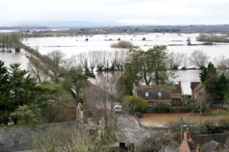
Ongoing Flood Threats Across the Nation
Concurrently, flood risks remain a serious concern. As of Sunday, there are 58 active flood warnings in England, with the majority concentrated in the counties of Somerset, Dorset, and Wiltshire. A further 118 flood alerts are in place across England, indicating areas where flooding is possible. In Wales, two flood alerts are active in Pembrokeshire and Powys, while Scotland has three flood warnings in force for the Tayside region and Orkney.
Major Incident Continues in Somerset
The situation remains particularly acute in Somerset, where a major incident was declared earlier in the week after approximately 50 properties were flooded due to Storm Chandra. On the Somerset Levels, authorities continue to deploy ultra high-volume pumps in an effort to remove standing floodwater. Somerset Council has warned that with further rainfall anticipated, additional homes in the Moorland, Saltmoor, and Currymoor areas could be at risk of flooding.
The Environment Agency has reported that water levels in the River Tone have now stabilised. To aid drainage, the Parrett flood relief channel has been opened, and contingency pumps have been installed at key locations including Aller Drove and Westonzoyland. These measures are part of a concerted effort to manage the excess water and mitigate further damage to communities already impacted by the severe weather.
Residents and travellers in the affected regions are strongly advised to stay informed via official weather updates, plan journeys carefully, and allow extra time for travel due to the potentially dangerous road conditions. The combination of ice, residual flooding, and possible fog presents a multifaceted hazard that requires heightened awareness and precaution.


