
A powerful bomb cyclone is poised to unleash its fury on the US East Coast this weekend, threatening millions of residents with freezing temperatures, significant snowfall and widespread power outages. The rapidly intensifying storm is currently forming off the coast of the Carolinas and is expected to move stateside, bringing severe weather conditions from the Southern US northward.
Impending Weather Chaos and Forecast Details
AccuWeather meteorologists have issued stark warnings about the storm's potential impact, with some parts of Massachusetts potentially receiving up to 12 inches of snow. Other affected regions including New England, Long Island, New York, New Jersey and Delaware could see accumulations of up to 6 inches, accompanied by blistering winds surging across most eastern states.
The extreme weather event is expected to cause massive disruption to travel plans, with huge flight delays anticipated from Friday as the storm initially hits the Southern US before tracking northward. Current predictions suggest the severe conditions will begin subsiding by Sunday, though the exact timeline remains subject to meteorological developments.

Understanding Bomb Cyclones and Their Formation
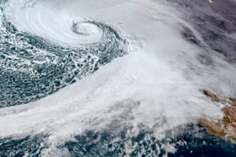
A bomb cyclone represents an extreme weather phenomenon caused by the rapid intensification of a cyclone within a very short timeframe, a process scientifically known as bombogenesis. These storms occur in mid-latitude regions between the tropics and polar areas when cold air masses collide violently with warm air masses over ocean waters.
Unlike hurricanes that typically form from warm, balmy ocean air, bomb cyclones (also called explosive cyclogenesis) develop specifically through this collision of contrasting air temperatures. According to the National Ocean Service, a storm must experience pressure drops of at least 24 millibars over 24 hours to qualify as a bomb cyclone.
Despite their ominous name, these weather events are relatively common occurrences. Research by Robert Fritzen at Northern Illinois University indicates North America experiences approximately 18 bomb cyclones annually, though their intensity and impacts vary considerably.
Recent Weather Context and Historical Comparisons
This incoming storm arrives just days after much of the country recovered from another severe snowstorm that brought historic low temperatures to some regions. Last week's megastorm left approximately one million people without power when more than a foot of snow blanketed 20 states.
Tragically, data reviewed by USA Today suggested the gruelling weather conditions killed at least 62 people as it battered communities across the nation. The timing of these consecutive storms highlights an increasingly volatile winter weather pattern affecting large portions of the United States.
Historically, the most intense cyclonic storm to strike the United States remains the 1993 "Storm of the Century," which stretched from Canada to Honduras. Forming over the Gulf of Mexico on March 12, that catastrophic event caused approximately $5.5 billion in damage, with some areas experiencing 100 mph winds that left around 10 million homes without power.
The 1993 storm resulted in an estimated 208 fatalities within the United States and 318 deaths across North America, with the New York Times famously describing it as "a monster with the heart of a blizzard and the soul of a hurricane."
Essential Safety Preparations and Expert Advice
Weather experts emphasize that proper preparation can significantly limit the dangers presented by bomb cyclones. According to guidance from The Weather Channel, residents in affected areas should ensure they are adequately stocked with food and water supplies before the storm arrives.
Maintaining a spare supply of batteries can help keep essential electronic devices operational during potential power outages. Securing loose outdoor items that could become dangerous projectiles in high winds is equally crucial for protecting both property and public safety.
Eco Flow recommends staying indoors during the storm's most intense phases, as bomb cyclones present multiple lethal risks. The extreme cold carries significant hypothermia dangers, while high winds can transform ordinary objects into deadly airborne missiles and create hazardous slipping conditions.

Reduced visibility from blowing snow substantially increases accident risks on roadways, making travel during the storm particularly dangerous. Following official weather advisories and heeding evacuation orders where issued remains paramount for personal safety during these extreme weather events.


