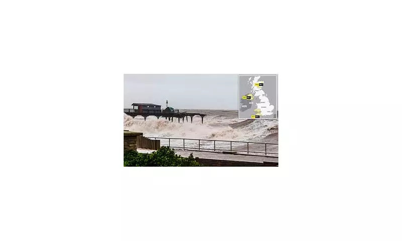
Significant sections of the historic Teignmouth Grand Pier have been washed away by the ferocious force of Storm Ingrid, as powerful gusts and torrential downpours continue to cause widespread disruption across the United Kingdom. Photographic evidence reveals huge chunks missing from the Victorian-era structure, which was originally constructed in 1865, after it endured a relentless battering from strong waves and heavy rain throughout the night.
Local Leaders Express Sadness Over Heritage Loss
Teignmouth mayor, Councillor Cate Williams, described the scene as profoundly 'sad', noting that the pier had 'taken a real battering'. In comments to the BBC, she elaborated on the structure's fragile state, explaining, 'It has lost part of the pier structure itself, that has dissolved and gone away into the sea.' Councillor Williams reflected on the pier's long history of resilience, stating, 'It's an old pier and it was needing some attention and I suppose age and wear and tear has taken its toll. It has survived many weather conditions as well as world wars. It's sad when you look at it now to see some of it now missing.'
Met Office Issues Severe Weather Warnings
The Met Office has issued stern warnings that further heavy rainfall throughout Saturday is highly likely to cause additional flooding and significant transport disruption, particularly in Devon and Cornwall. A yellow weather warning for rain remains in effect until 10pm, covering extensive areas including parts of Scotland, southern Wales, and Northern Ireland.

Flood Risk Reaches Critical Levels
Flooding continues to present a major national risk, with the Environment Agency currently issuing 16 active flood warnings alongside 135 flood alerts across England. A Met Office spokesman provided detailed analysis of the dangerous conditions: 'With ground conditions saturated in many places, further flooding of roads and flowing water from fields is likely even with modest amounts of rainfall, leading to difficult driving conditions and roads potentially becoming impassable at times. Although not as strong as yesterday, winds approaching gale force during Saturday morning may continue to exacerbate impacts at times, particularly along the English Channel coastline.'
Transport Networks Face Severe Disruption
The severe weather has crippled transport infrastructure across affected regions. Great Western Railway has urgently advised passengers against travelling between Exeter St Davids and Newton Abbot on Saturday morning due to complete line suspension. The company anticipates disruption continuing until approximately 7pm following severe weather damage to the Dawlish sea wall. Additionally, the line between Par and Newquay has been closed, with disruption expected until 5pm.
Martin Wrigley, the MP for Newton Abbott, expressed his disappointment at the damage, stating: 'Seeing the damage to the sea wall in Dawlish is really disappointing. That means the railway line will need fixing before it can be reopened but hopefully they will get it done quickly.' He further emphasised the need for improved resilience, adding, 'Network Rail need to do more to make our railway fully resilient.'
Scotland Braces for Further Flooding
Meanwhile, the Met Office has warned that parts of northeast Scotland could face additional flooding and travel disruption as a yellow weather warning for rain extends into the weekend. This warning, covering the Grampian, Angus and Perth regions, came into effect at midnight and remains active until 9am on Sunday. On Saturday morning, the Scottish Environment Protection Agency had issued 11 flood warnings and four flood alerts.
A Met Office spokesman detailed the Scottish situation: 'Following a three-day spell of very wet weather across this region, with some places having seen in excess of 100mm, a further day of fairly persistent and at times heavy rain is expected, before easing during Saturday night. Many places are likely to see a further 20-30mm of rain, and a few spots could see 50mm. Above 400-500 metres, however, a lot of this will fall as snow, with rain confined to areas of ground below this level.'

Rescue Operations and Government Response
The severe conditions have necessitated emergency rescues, with three people in Aberdeenshire requiring extraction from their stranded vehicles by firefighters. Two individuals were rescued from a minibus on the B977 near Kintore around 8.30am on Thursday, while another person was brought to safety from a car in a separate incident near Banchory at approximately the same time.
The Scottish Government Resilience Room convened on Thursday to address the escalating weather situation. Justice Secretary Angela Constance, who chaired the meeting, urged public vigilance: 'I would urge people to pay attention to flood alerts, weather forecasts and to consider travel updates in their area.'
Further Weather Hazards Forecast
Forecasters have additionally warned of potential 'wintry hazards' developing next week across northern and eastern regions of the UK, with some areas likely to experience snowfall. Another Met Office yellow warning for rain has been issued, covering large parts of southwest England and south Wales from 6pm on Monday through to 2pm on Tuesday, indicating that the period of unsettled weather is far from over.
ScotRail has implemented speed restrictions on the line between Aberdeen and Inverness due to the adverse weather, resulting in significantly slower journey times. The line towards Dundee experienced additional disruption after becoming blocked by a fallen tree, further complicating travel across the region.