
UK Faces Icy Peril in Wake of Storm Chandra's Destructive Flooding
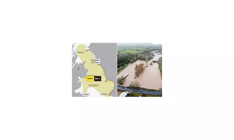
Britain is set for a hazardous freeze overnight, with pavements and roads expected to turn treacherous, following the devastating impact of Storm Chandra which brought life-threatening flooding to numerous regions on Tuesday. The Met Office has now issued a fresh yellow weather warning for ice, covering extensive areas of England, Scotland, and Wales, effective from midnight until 10am on Wednesday.
With temperatures predicted to plummet below freezing, forecasters have urgently advised the public to take precautions to avoid injuries from slips and falls on icy surfaces. Particularly in the Highlands, temperatures could drop to around -2°C in the early morning hours. Untreated roads, pavements, and cycle paths are most likely to develop dangerous patches of ice.
Commuters Urged to Exercise Extreme Caution
Those travelling to work on Wednesday morning have been strongly encouraged to check for delays and road closures, allow extra time for their journeys, and ensure their vehicles are in proper working order before departure. This ice warning comes just hours after Storm Chandra unleashed torrential rain and fierce winds across the UK, leading to severe flooding and setting new January daily rainfall records in several locations.

The Met Office had previously issued nine yellow or amber weather warnings, anticipating up to 80mm of rain, 20cm of snow, and gusts reaching 80mph. Provisional data indicates that at least six UK locations recorded their wettest January day, with Katesbridge in Northern Ireland measuring 100.8mm. Other notable records include Dunkeswell in Devon at 52.8mm, and Plymouth in Devon at 43.2mm.
Emergency Services Battle Widespread Flooding
Firefighters in Devon performed dramatic rescues, saving people from 25 vehicles trapped in floodwater on Tuesday. The River Otter near Ottery St Mary in Devon surged to its highest recorded level, prompting a severe flood warning. Hundreds of communities remained on high alert after the Environment Agency issued two 'danger to life' severe warnings for the Otter and the Upper Frome at Dorchester in Dorset, alongside 89 warnings for expected flooding and 237 alerts across England.
Dozens of homes were inundated, while Natural Resources Wales issued 18 alerts and the Scottish Environment Protection Agency had two warnings and 18 alerts active. The 35-hour low pressure system continued to affect the country, including London, after sweeping into South West England on Monday afternoon.
Significant Travel Disruption and School Closures
The strongest winds battered the South West and Wales, with gusts potentially hitting 80mph in Pembrokeshire and the Isles of Scilly. A succession of Atlantic weather systems drove wet and windy conditions nationwide, with snow likely on higher ground in the Pennines and Scottish mountains. Meanwhile, the UK Health Security Agency activated cold health alerts for northern England from Monday night until Friday, highlighting a greater risk to life for vulnerable individuals.
Transport networks faced severe disruption. The M48 Severn Bridge was closed, and the Humber Bridge restricted high-sided vehicles. National Rail reported multiple line closures due to flooding, affecting routes in Cornwall, Somerset, Wiltshire, Hampshire, and Devon. Over 280 schools closed across Northern Ireland, and more than 40 in Devon, as authorities urged people to avoid non-essential travel.
Record River Levels and Ongoing Risks
The Environment Agency confirmed the River Otter at Fenny Bridges reached its highest recorded level at 2.83m, surpassing the previous record from December 2000. East Devon received 67mm of rain in 12 hours, with 88mm recorded at Whitebarrow on Dartmoor. Approximately 20 properties have flooded, with numbers expected to rise.
Richard Foord, Liberal Democrat MP for Honiton and Sidmouth, praised council staff, the Environment Agency, and emergency services for their efforts during the storm. He emphasised the severity of the situation, noting the unprecedented river levels and ongoing risks.

Further Weather Warnings and Safety Advice
Additional amber warnings for wind affected eastern Northern Ireland, while amber rain warnings covered south Devon, Dorset, southern Somerset, and south-east Cornwall. Yellow warnings for rain, snow, and wind were in place across various regions, including southern England, northern England, and Scotland.
Met Office chief forecaster Paul Gundersen warned of complex hazards, including strong winds, heavy rain on saturated ground, and significant snow accumulations. The RAC advised drivers to avoid standing water, slow down, and ensure vehicle safety. As Storm Chandra, named by the western Europe storm naming group, moves on, the UK now confronts the dual challenge of recovery from flooding and preparation for icy conditions.


