
Advanced weather modelling maps are indicating that Britons could face a potentially "devastating" weather phenomenon at the very start of February, with significant snowfall accompanied by the rare and hazardous occurrence of freezing rain.
Widespread Snow and Freezing Rain Forecast
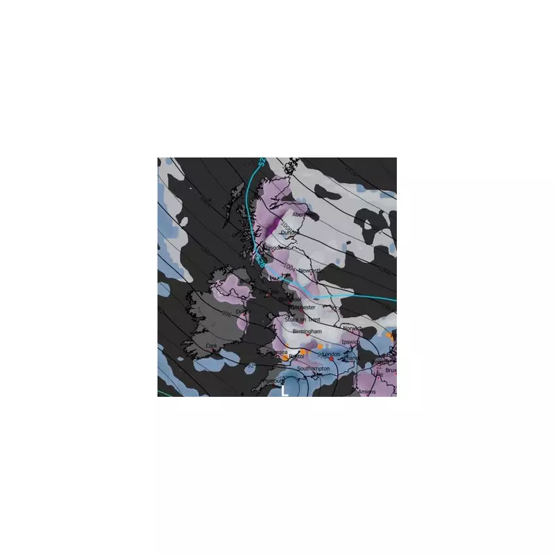
The latest GFS weather model projections show that snow and rain could engulf large parts of the country on Tuesday, February 4th. The white stuff is expected to settle on the ground from the south of England all the way up to the far north of Scotland, with Wales and Northern Ireland also likely to experience flurries.
Areas marked in purple on the forecasting maps indicate settled snow in several major UK cities. These include Southampton, London, Birmingham, Nottingham, Cardiff, Norwich, Newcastle, Edinburgh, and Glasgow. However, meteorological experts warn that snow may not be the only significant hazard facing the nation.

The Threat of Freezing Rain
Distinct orange patches on the same weather maps highlight regions where the dangerous phenomenon of 'freezing rain' could strike. At 9am on February 4th, this risk is concentrated over South Wales, Gloucestershire, and Buckinghamshire. Later in the afternoon, the modelling suggests central Wales could also be affected.
More freezing rain is anticipated around midday, extending the period of risk for these areas. This specific type of precipitation poses a far greater danger than standard snowfall due to its immediate freezing properties upon contact with cold surfaces.
What Exactly is Freezing Rain?
The Met Office provides a clear explanation, describing freezing rain as "a rare type of liquid precipitation" which freezes almost instantly the moment it lands on any cold surface. It forms through a precise atmospheric process.
Precipitation initially falls as snow high in the atmosphere. It then passes through a layer of warmer air, which causes it to melt and become rain. If this rain then descends through another layer of sub-zero air close to the ground, it becomes "supercooled."
This means the droplets maintain a liquid state despite having a temperature below 0°C. "When this 'supercooled' droplet hits the ground (which is below 0°C too) it spreads out a little on landing, and then instantly freezes, encasing the surface in a layer of clear ice," the Met Office states. "This is why it is called freezing rain."
Significant Dangers and Historical Context
The hazards associated with freezing rain are severe. The Met Office warns that the weight of the clear ice it creates can be "heavy enough to bring down trees and power lines," causing widespread disruption. It also "turns roads and pathways into an ice rink," creating treacherous conditions for drivers and pedestrians alike. The aviation sector is also at risk, as freezing rain can prove "extremely hazardous" for aircraft.
A historical Met Office case study detailing the impact of a freezing rain event across Wales, the South-West, and the Midlands in 1996 starkly notes: "The consequences can be devastating." That event led to a marked increase in road traffic accidents and hospital admissions.
Thankfully, early analysis suggests the freezing rain shown on the latest forecast maps for early February is not expected to be as prolonged or as widespread as the severe 1996 episode. Nevertheless, authorities are urging the public to stay informed through official weather warnings and to prepare for potentially difficult travel conditions and the risk of localised disruption during this period of wintry weather.


