
A powerful and dangerous 'bomb cyclone' is poised to slam into the US West Coast on Christmas Eve, threatening to bring severe flooding, landslides, and hurricane-force winds that will severely disrupt holiday travel plans.
Severe Warnings for Coastal California
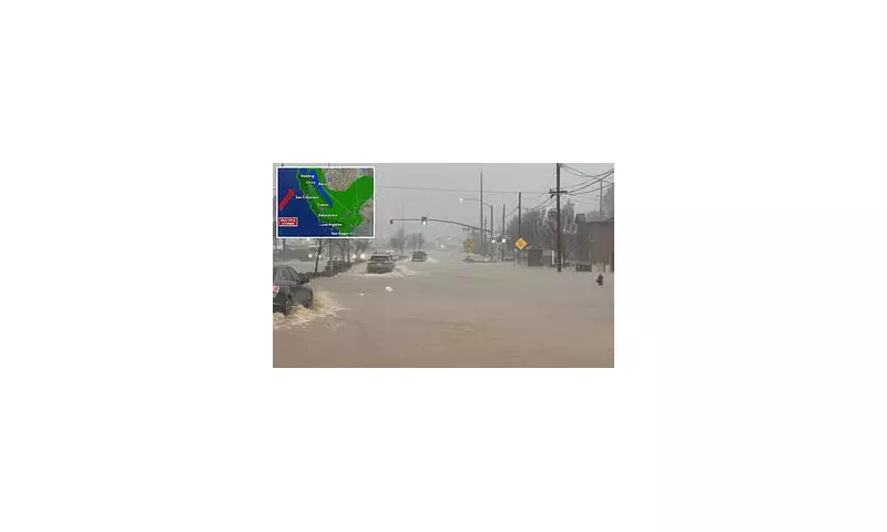
The entire California coastline is under a severe storm warning this morning. Major cities from San Francisco to Los Angeles are bracing for at least two to four inches of rain, with winds potentially reaching 70mph in parts of the Bay Area and Northern California.
Inland areas face an even more extreme threat from a concentrated 'firehose' of rainfall, which could dump a staggering eight to 16 inches of rain in regions including the Los Angeles basin and the Sierra Nevada mountains.

Travel Chaos and Mounting Dangers
The storm's timing could not be worse for festive travel. Between Tuesday and Christmas Day, over 1,300 flights are expected to be cancelled at airports in San Francisco, Los Angeles, San Diego, and numerous smaller hubs.
This tempest is the second 'atmospheric river' – a long, narrow band of intense moisture – to hit the state in a week. The first river caused deadly flooding in Northern California, killing at least one person in Redding after nearly 10 inches of rain fell in 24 hours.
On Christmas Eve, the heaviest downpours from this second system are forecast, with one to three-inch deluges expected along coastal plains. Southern California, including Los Angeles and San Diego, faces a high risk of flash flooding and landslides, potentially making it one of the wettest Christmas Eves on record.
Bomb Cyclone Formation and Further Impacts
Forecasters warn this storm could officially intensify into a 'bomb cyclone' if the central air pressure drops rapidly by at least 24 millibars within 24 hours. This explosive strengthening would pull in hurricane-force winds and heavier rain.
AccuWeather's chief meteorologist Bernie Rayno has predicted staggering snowfall totals, stating, 'We're probably looking at at least 10 feet of snow this week over the ridges and peaks of the Sierra Nevada.' The National Weather Service has issued winter storm warnings for mountainous areas.
Beyond travel, the storm brings widespread risks. Wind gusts of 40-60mph threaten power outages and fallen trees. Flooding is anticipated in urban areas, along rivers, and in burn scars left by recent wildfires. AccuWeather's Brandon Buckingham cautioned that regardless of the precise pressure drop, the storm will intensify enough to create dangerous conditions along the Northern and Central California coast.
As of Tuesday morning, the ripple effects were already being felt, with over 1,500 flights delayed globally and routes between New York and Los Angeles among the most affected.


