
Emergency 'Charge Phone Now' Warning as Storm Chandra Prepares Second Strike
The Irish meteorological service, Met Éireann, has issued a critical warning to homeowners across the nation, urging immediate preparation as Storm Chandra is forecast to swing back around for a second devastating assault. This colossal low-pressure system, which initially battered the Republic of Ireland with heavy downpours and fierce winds on Tuesday morning, is now poised to deliver additional waves of severe weather.
Dire Forecast and Extended Weather Alerts
Meteorologists have described the situation as a "multi-hazard event", with the forecast including significant risks of flooding, widespread power cuts, toppled trees, and extremely dangerous travel conditions. In response, Met Éireann has delivered specific guidance to the public, strongly advising households to ensure all mobile devices are fully charged in advance of the storm's return.
The official guidance states: "Ensure your mobile phone is fully charged to enable communication in advance of the event and keep local emergency numbers in your phone." This precaution is considered vital for maintaining contact with emergency services and receiving critical updates as conditions deteriorate.

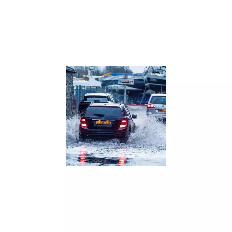
Widespread Disruption and National Warnings
Two yellow-level weather alerts remain in force across Ireland and are not scheduled to lift until nearly midnight. Initially, a yellow wind warning covered seven counties, but it has since been extended to encompass the entire nation until 11pm. A separate yellow rain warning applies specifically to the counties of Carlow, Kilkenny, Louth, Wexford, Wicklow, and Waterford, also lasting until 11pm.
The national weather service provided a detailed explanation of the expected conditions: "Initially a band of persistent rain will push up from the southeast bringing widespread rainfall. The system is forecast to meet a relatively cool airmass as it moves northwards, bringing the potential for mixed precipitation with a chance of falls of sleet over higher ground in the north and northwest in the morning."
It further warned: "This rain will clear northwards and will be followed by a brief period of drier and brighter weather before the same system swings back around and feeds further outbreaks of rain up over the country. Wet and windy conditions will affect all areas with southern and eastern counties expected to see the highest rainfall accumulations."
Significant Impact on Infrastructure and Travel
The storm has already caused substantial disruption across Ireland. At 11am, approximately 20,000 homes, farms, and businesses remained without electricity. Dublin Fire Brigade confirmed it had attended several flooding incidents across the capital city, highlighting the immediate dangers posed by the severe weather.
Transport networks have been severely affected. Iarnród Éireann announced significant disruptions to Dart services, while numerous ferry crossings between Dublin and Holyhead have been cancelled entirely. Dublin Airport has also warned passengers that flight cancellations could occur as conditions worsen.
Expert Analysis and Safety Advice
Met Éireann forecaster Rebecca Cantwell provided a comprehensive analysis of the situation: "Storm Chandra is a low-pressure system that will track northwards over the country Monday night and Tuesday, bringing with it rather wet and windy conditions. It will bring heavy spells of rain with strong winds, especially along the coast."
She emphasised the compounding factors: "Given the unsettled spell of weather we've experienced over the last while, this rain will fall on already saturated ground, combined with the fact that many rivers are approaching or exceeding bank-full conditions, and so we are expecting localised flooding and river flooding as a result."
Cantwell also addressed the wind threat: "This rain will also be accompanied by strong and gusty winds, affecting especially coastal areas, and a yellow wind warning has been issued for the entire country. The compound effect of the wind and rain will make for some difficult travelling conditions during the validity period of the warnings."

The forecaster concluded with crucial safety advice, echoing the Irish Coast Guard: "The winds will be strongest near coasts and exposed areas with wave overtopping possible and so we echo the well-known advice: 'Stay Back, Stay High, Stay Dry'. In summary, stay back from rivers, lakes and the coasts and avoid flooded roads, following the latest guidance from your local authority and road authorities."
Residents across Ireland are urged to heed all warnings, prepare emergency supplies, ensure communication devices are charged, and avoid unnecessary travel as Storm Chandra delivers its second powerful strike.


