UK Braces for Severe Storm with 70mph Winds and Arctic Chill
The Met Office has escalated weather alerts, issuing yellow warnings for high winds expected to reach speeds of up to 70mph across 11 key regions of the United Kingdom. This stormy onslaught is forecast for Thursday, prompting urgent calls for residents to implement three critical safety measures to protect themselves and their properties.
Widespread Wind Warnings and Impending Arctic Conditions
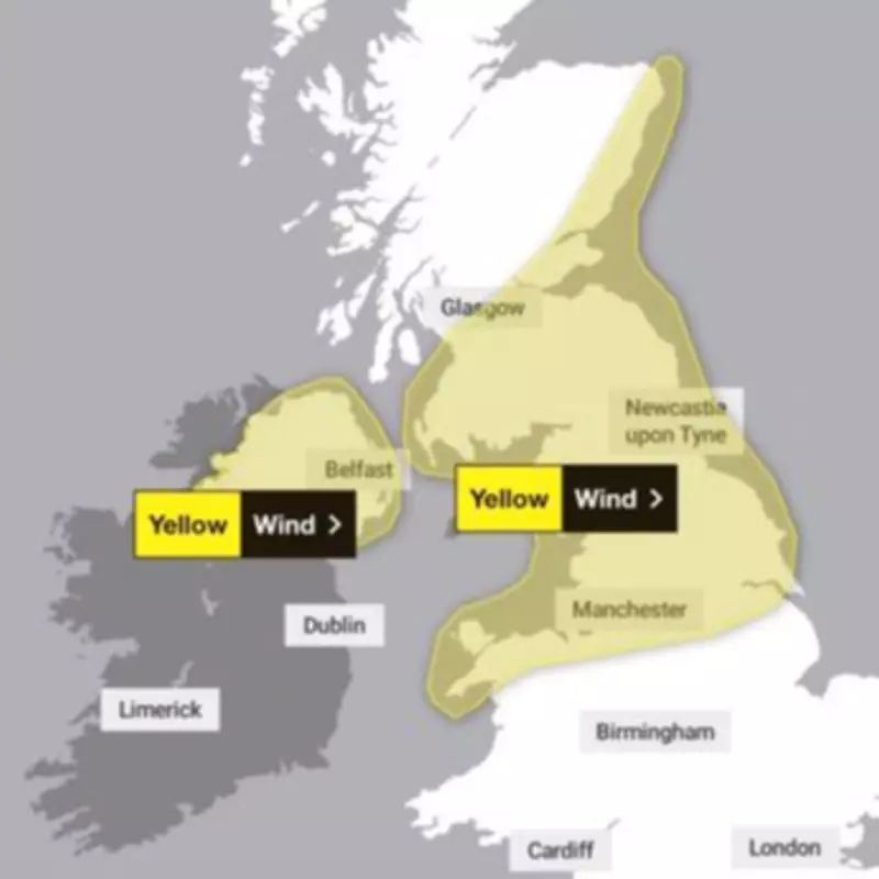
Two separate yellow wind warnings have been activated, covering extensive areas of northern England, Wales, Scotland, and Northern Ireland. These alerts come on the heels of a week marked by persistent rainfall, with low-pressure systems now advancing from the northwest to unleash powerful gusts. The Met Office cautions that once the storm subsides, an Arctic blast will sweep across the nation, causing temperatures to plummet sharply. In northern regions, thermometers could dip as low as -2C by the weekend, exacerbating the hazardous conditions.
Today, the fiercest winds are concentrated in northern Scotland, but the blustery weather is predicted to migrate southward by Thursday. The primary warning, effective from 5am to 8pm, spans northern England, Wales, and parts of Scotland, with forecasts indicating widespread gusts of 50-55mph. Coastal locales and areas adjacent to high ground may experience even stronger winds, potentially hitting 60-70mph. A secondary alert for Northern Ireland is scheduled from 6am to midday, highlighting the broad impact of this weather event.

Essential Safety Guidance from the Met Office
In response to the impending storm, the Met Office has outlined three vital steps for public safety:
- Travel Preparedness: Check road conditions, bus and train timetables before embarking on journeys, and adjust plans accordingly to avoid delays.
- Power Outage Readiness: Assemble emergency kits including torches, batteries, and mobile phone power packs to mitigate disruptions during potential blackouts.
- Coastal and Cliff Safety: Exercise extreme caution near coastlines due to large, dangerous waves, and keep dogs on leads when walking near cliffs. In emergencies, contact the Coastguard immediately by dialing 999.
The forecast for Thursday anticipates rain and strong winds moving southeastward, with intermittent bright spells and showers trailing behind. A noticeable drop in temperature is expected, particularly in northern areas, as the day progresses.
Affected Regions Under Wind Weather Warning
The 11 areas facing the brunt of the storm include:
- Central, Tayside & Fife: Angus, Clackmannanshire, Dundee, Falkirk, Fife, Perth and Kinross, Stirling
- East Midlands: Derbyshire, Lincolnshire, Nottinghamshire
- Grampian: Aberdeen, Aberdeenshire
- North East England: Darlington, Durham, Gateshead, Hartlepool, Middlesbrough, Newcastle upon Tyne, North Tyneside, Northumberland, Redcar and Cleveland, South Tyneside, Stockton-on-Tees, Sunderland
- North West England: Blackburn with Darwen, Blackpool, Cheshire East, Cheshire West and Chester, Cumbria, Greater Manchester, Halton, Lancashire, Merseyside, Warrington
- SW Scotland, Lothian Borders: Dumfries and Galloway, East Lothian, Edinburgh, Midlothian Council, Scottish Borders, West Lothian
- Strathclyde: East Ayrshire, East Dunbartonshire, East Renfrewshire, Glasgow, North Ayrshire, North Lanarkshire, South Ayrshire, South Lanarkshire
- Wales: Conwy, Denbighshire, Flintshire, Gwynedd, Isle of Anglesey, Wrexham
- West Midlands: Staffordshire
- Yorkshire & Humber: East Riding of Yorkshire, Kingston upon Hull, North East Lincolnshire, North Lincolnshire, North Yorkshire, South Yorkshire, West Yorkshire, York
- Northern Ireland: County Antrim, County Armagh, County Down, County Fermanagh, County Londonderry, County Tyrone
Residents in these zones are advised to stay vigilant and adhere to official guidance as the storm unfolds.