
Unseasonal Snow Forecast to Hit a Dozen UK Cities This Weekend
Advanced meteorological modelling indicates a surprising bout of wintry weather is poised to sweep across the United Kingdom this Saturday. Forecasting maps from the GFS model reveal that as many as twelve major urban centres could experience unexpected snow flurries, marking a stark contrast to the recent warm spell.
Weather Front Brings Wintry Mix from Atlantic
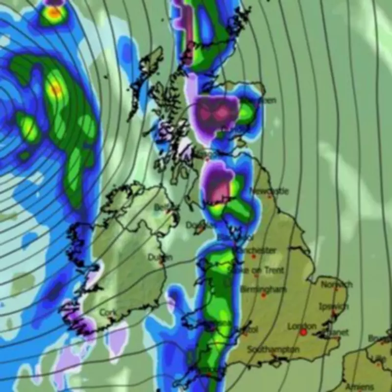
The anticipated precipitation event is forecast to originate from the Atlantic in the early hours of Saturday morning. Initially, this system is projected to deliver rain to Wales and the southwestern regions of England. However, as the cold air interacts with this moisture, the precipitation is expected to fall as snow across Scotland initially, before the wintry conditions propagate southwards throughout the morning.
By 6am on Saturday, mapping data suggests snow, indicated by purple shading, will be falling across extensive areas of Wales, the northwest of England, and parts of Scotland. There is even a possibility for some flurries to reach the southwestern peninsula of England.

By 9am, the snow coverage is forecast to extend further, potentially affecting the Midlands and northeastern England. Throughout this period, the cumulative data points to at least a dozen significant cities witnessing some snowfall.
The Cities in the Path of the Flurries
The following major urban areas have been identified as likely to see snow on Saturday:
- Swansea
- Birmingham
- Coventry
- Stoke-on-Trent
- Manchester
- Sheffield
- Leeds
- Newcastle
- Durham
- Edinburgh
- Glasgow
- Dundee
Snow coverage maps indicate that most of Scotland, northern England, and Wales could see some flakes settling on the ground. However, forecasters emphasise that accumulations are likely to be minimal, generally not exceeding 1 centimetre, except potentially over higher ground and hills in Scotland.
Temperature Drop and Official Forecasts
This cold snap represents a significant shift from the unseasonably warm conditions experienced earlier in the week, which saw temperatures soar to 26°C in some areas. The Met Office predicts temperatures will peak at a much cooler 15°C in southern regions on Saturday.
The official Met Office forecast for Saturday states: “Rain across central and western areas, but clearing eastwards. Showers follow, heavy in Northern Ireland and western Scotland. Windy with coastal gales in the west. Temperatures near seasonal average.”
Meanwhile, BBC Weather anticipates a cloudy start to the day tomorrow with a risk of showers in western parts. Their outlook suggests: “Tomorrow will start mostly cloudy, with rain reaching the south-east, and showers in the west. In the afternoon, the risk of showers will persist but some sunny spells will develop. Windy in the west.”
The unsettled conditions are expected to continue into the start of the new week, with Sunday forecast to be breezy with sunny spells and showers, some potentially turning thundery in the afternoon. Monday should see easing winds but a continued mix of sunshine and showers, mainly in the north, before a mostly dry Tuesday.


