
Tropical Cyclone Mitchell Intensifies to Category Three, Threatens WA Coast
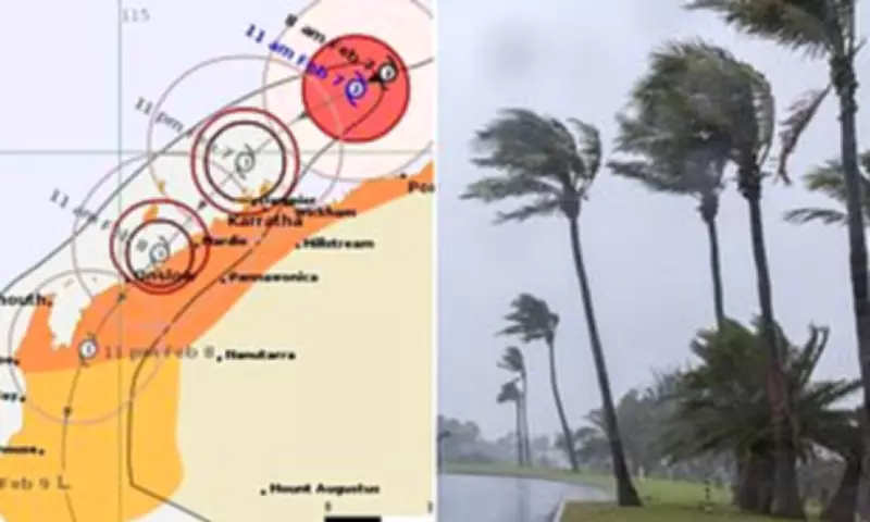
Tropical Cyclone Mitchell has rapidly intensified into a severe category three system off the northern coast of Western Australia, posing a significant threat to communities along the Pilbara coastline. The cyclone, which was located offshore of Port Hedland and moving southwest towards Karratha late Saturday morning, is expected to continue churning southwest and make landfall late Sunday afternoon.
Destructive Winds and Immediate Warnings
According to the Bureau of Meteorology, very destructive wind gusts could reach speeds of up to 170km/h. These dangerous conditions are forecast to impact areas around Karratha, Dampier, and Wickham on Saturday night, with Onslow further south facing similar threats during Sunday. A watch and act warning is currently in place for the region from Whim Creek to Mardie, including Barrow Island and Montebello Islands.
Residents in these areas have been instructed to prepare to take immediate shelter due to the potential threat to lives and homes. Authorities have advised those from Pardoo Roadhouse to the east of Whim Creek, and from south of Mardie to Carnarvon and Pannawonica, to closely monitor conditions and ready themselves for dangerous weather.

Evacuation and Port Closures
An evacuation centre was opened at the Karratha Leisureplex from midday on Saturday. People seeking refuge are advised to bring essential items such as medication and identification, but pets are not permitted. Simultaneously, major ports along the WA coast have been closed as a precautionary measure.
The ports of Ashburton, Cape Preston West, Dampier, Port Hedland, and Varanus Island have all been shut down in anticipation of the cyclone's arrival. This disruption highlights the severe impact on regional infrastructure and maritime activities.
Heavy Rainfall and Flood Risks
Up to 130mm of rain is predicted for Port Hedland on Saturday alone, significantly increasing the risk of flash floods. Authorities warn that the central and west Pilbara coast faces a high risk of flash flooding throughout the weekend, with the west Gascoyne region likely to be affected by Monday.
The Bureau of Meteorology has also issued warnings about abnormally high tides, which present a serious flood risk for the Karratha region in the early hours of Sunday and towards Onslow Sunday afternoon. These combined factors—heavy rain, strong winds, and high tides—create a perfect storm for widespread flooding and damage.
Broader Regional Impact
The cyclone's impending arrival comes as other outback towns are still grappling with the aftermath of major flooding. In the Northern Territory, more than 400 people were bussed 230km to Darwin from Daly River on Wednesday. These evacuees, including 110 children, are housed at the Foskey Pavilion at the Darwin Showgrounds and may have to wait days before returning home, as riverine flooding is not expected to peak until early next week.
Incident controller Superintendent David Moore emphasized the ongoing challenges, noting that the situation remains fluid and dangerous. The dual crises of cyclone threats in WA and persistent flooding in the NT underscore the severe weather patterns affecting northern Australia.
Residents across the Pilbara and Gascoyne regions are urged to stay informed through official channels, follow all safety advisories, and prepare for potentially life-threatening conditions as Tropical Cyclone Mitchell continues its path along the coast.


