
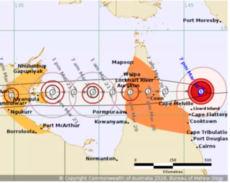
Tropical Cyclone Narelle Intensifies to Category 5, Threatening Queensland Coast
The Bureau of Meteorology has issued urgent warnings as Severe Tropical Cyclone Narelle rapidly intensified into a category 5 storm, with destructive wind gusts reaching 315km/h. The monster cyclone is barrelling west towards the far north Queensland coast, expected to make landfall at 7am on Friday morning. This marks a significant escalation from earlier forecasts, with the bureau revising the timing forward by three hours due to the storm's swift movement at approximately 20km/h.
Emergency Preparations Underway as Communities Brace for Impact
Vulnerable residents have been evacuated from the warning zone, while tourists caught the last remaining flights out of the region. More than 100 emergency services personnel have been deployed north, with police conducting door-to-door checks to ensure locals are prepared. Schools have been closed, affecting about 780 students across eight institutions, with further closures likely on Friday. Shipping containers of essential supplies have arrived, and emergency generators are on standby, as the region anticipates widespread power outages.
Queensland Premier David Crisafulli emphasised the severity of the situation, stating, "This is a serious system, and I'm asking people to take it seriously. Because it is the kind of event that doesn't happen all that often. If a category 5 system crosses the Queensland coast, it will be just the fourth time that has happened in half a century. I can't sugar-coat this. The damage will be widespread."

Historical Context and Climate Factors
Narelle would be the first category 5 cyclone to hit the Cape York region since Cyclone Mahina in March 1899, which killed more than 300 people. The most recent category 5 storm to cross the Australian coastline was Ilsa in April 2023, while Queensland's last was Marcia in 2015. According to climate scientist Andrew Watkins from Monash University and the Climate Council, the Coral Sea has experienced record sea surface temperatures, with waters 1C to 2C warmer than average along Narelle's track. "Warmer ocean temperatures are fuel for tropical cyclones," Watkins noted, highlighting the role of climate change in intensifying such events.
Forecasted Impacts and Regional Threats
The Bureau of Meteorology forecaster Angus Hines warned of heavy rainfall between 150mm and 300mm for the Cape York region, with up to 450mm possible in some areas, leading to flash flooding and rising river levels. "That is enough to cause flash flooding and cause river levels to climb so we should expect flooding as the rain works its way through the river systems," Hines said. After landfall, Narelle is expected to move over the Gulf of Carpentaria and cross the Top End as a category 3 system by Saturday evening, potentially affecting areas south of Darwin, including Katherine and Daly River, which have recently faced devastating floods.
Hines also indicated that Narelle could make a third land crossing next week after moving over the Indian Ocean, where conditions remain conducive to cyclone development. The storm's rapid intensification has been fuelled by warm waters in the Coral Sea, favourable wind conditions, and its speed, making it one of the most significant weather events in recent memory for the region.


