
UK Braces for Intense Blizzard with Four-Inch-Per-Hour Snowfall Rates
Advanced weather forecasting models are warning of a potentially severe blizzard set to sweep across the United Kingdom later this week, with snowfall rates reaching an astonishing four inches per hour in some regions. According to the latest data from the GFS weather model, this powerful winter storm could blanket a vast 600-mile stretch, impacting Scotland, England, Wales, and Northern Ireland simultaneously.
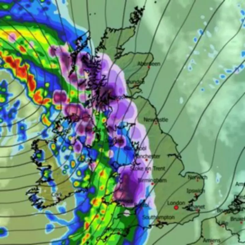
Timeline and Geographic Impact of the Impending Snowstorm
Precipitation maps indicate that a formidable band of wintry weather will push in from the Atlantic overnight, initially striking western parts of the UK before spreading eastwards by approximately 3am on Sunday. Major urban centres including Manchester, Birmingham, Stoke-on-Trent, Newcastle, Glasgow, and Dundee are expected to experience significant snowfall during the early hours. Meanwhile, other key cities such as Belfast, Bristol, Plymouth, and London are likely to encounter cold rain initially, with conditions deteriorating to sleet as the system progresses.
By 6am, the meteorological system is projected to advance further east, bringing wintry conditions to areas including London, Norwich, and Ipswich. Snow depth maps suggest that widespread snowfall will be established across much of the country by around 9am, with the most intense accumulations concentrated in Scotland. Specifically, parts of the Cairngorms and eastern Highlands could receive up to twenty inches of snow, particularly on elevated terrain.

Regional Snowfall Predictions and Accumulation Forecasts
Scotland: Eastern regions, including areas around Dundee, Angus, and eastern Perthshire, are anticipated to see accumulations of four to six inches. The heaviest snowfall is firmly expected in the Highlands, where higher ground may experience the most extreme conditions.
Northern England: Counties such as Northumberland, Cumbria, and the Pennines could witness several inches of snow, with greater totals predicted over hills and mountainous areas.
Midlands and Wales: These regions are forecast to receive lighter snowfall, though still significant enough to cause travel disruptions and hazardous conditions.
Southern England: Much of the south is likely to experience patchy snow, sleet, or icy rain, with the potential for slippery roads and reduced visibility.
Met Office Long-Range Forecast and Broader Weather Patterns
In its extended forecast covering February 14 to February 23, the Met Office highlights that Atlantic frontal zones are poised to return at the start of the period. These atmospheric boundaries in the North Atlantic, where contrasting air masses converge, can generate low-pressure systems and usher in unsettled weather patterns. The national forecaster notes, "The track of these depressions may be a little further north than over the preceding weeks, but will continue to bring broadly unsettled weather to many areas, with further spells of rain and perhaps strong winds at times."
The Met Office adds that a westerly influence should result in somewhat milder conditions for many regions, though colder conditions could intermittently affect northern and northeastern parts. Looking ahead to the immediate days, Tuesday is forecast to begin dull with outbreaks of rain and drizzle, followed by heavy rain moving into the south before sunshine and showers emerge. The remainder of the UK is expected to stay cloudy and damp.
For Wednesday through Friday, the outlook remains unsettled initially with further outbreaks of rain for many areas. A turning point is anticipated on Friday as conditions become colder and brighter, bringing a chance of snow showers, particularly in the north and east. This evolving weather scenario underscores the need for vigilance and preparedness as the UK faces a significant winter weather event with potentially rapid and heavy snowfall.


