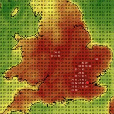
Thunderstorm warnings are in place for much of England on what could be the hottest May day since records began. A yellow weather warning has been issued for parts of the South West, West Midlands, East Midlands and East of England between 3pm and 10pm on Tuesday.
Isolated thunderstorms with lightning, hail and gusty winds are expected, the Met Office said, while there is potential for 30mm of rain in less than an hour. Meanwhile, the hottest May temperature could be broken again on Tuesday with highs of 35C forecast across large swathes of southern England and Wales – which could even creep up to 36C, the Met Office said, although this could be reduced by the storms.
On Monday, the UK recorded its provisional all-time hottest meteorological spring temperature when Kew Gardens in south-west London hit 34.8C. The country also experienced a “tropical night” as the record for the warmest minimum temperature for May was broken for the second consecutive day. Temperatures did not fall below 20C overnight on Monday in parts of the UK, with 21.3C recorded at Kenley Airfield, south London.

Many places across England and Wales will reach the heatwave threshold on Tuesday and some will have had five days of it by Wednesday, said Becky Mitchell, senior meteorologist at the Met Office. Heatwave conditions were already met in eight parts of England by Sunday night: Heathrow, Kew Gardens and Northolt in London; Benson in Oxfordshire; Brooms Barn and Santon Downham in Suffolk; High Beech and Writtle in Essex. That number will be higher after the bank holiday weather but the data is yet to be released, Ms Mitchell said. To qualify as a heatwave, temperatures must meet or surpass a specific threshold for three consecutive days. The highest heatwave threshold in the UK at this time of year is 28C, which applies to London and areas north of the capital towards Cambridgeshire.
Temperatures will start to gradually decline from the middle of the week but it will still be largely dry with sunny spells. Many will still experience temperatures in the high 20s. However, they will lower by around 10C in eastern areas as a brisk easterly wind develops.
If validated, the latest May record means seven of the 12 monthly highs have been set since 2003, the Met Office said. A previous study by the forecasters found breaking that record “is around three times more likely now in our current climate than it would have been in a natural climate not impacted by greenhouse gas emissions”. This means that the event once judged a one-in-a-100-year event is now a one-in-33-year event, it said.
In contrast, there were lows of minus 5C in Scotland last week when daytime temperatures more widely peaked at about 14C to 15C. Amid the bank holiday heat, firefighters worked through the night to tackle a grass fire near Arthur’s Seat in Edinburgh as temperatures in the city hit 25C. Clouds of smoke were seen rising from the area around the natural landmark and local residents were advised to keep their windows and doors shut as a precaution.
On Monday, a 13-year-old boy also died after getting into difficulty in a West Yorkshire reservoir. West Yorkshire Police said the teenage boy was pulled from the water and taken to hospital, where he was pronounced dead. Meanwhile, the AA warned that the interior of vehicles can reach 60C on a day when the outside temperature is 27C. The heat is considered to be dangerous for some vulnerable groups including older adults as their bodies struggle to regulate temperature. Age UK recommended staying inside during the hottest hours of the day, between 11am and 3pm, and having regular cold baths or showers.