
UK Braces for Continued Flooding as Rain Shows No Sign of Abating
Forecasters have issued a stark warning that there is no sign of a prolonged dry spell for at least the next week, as more than 100 flood warnings remain in place across the United Kingdom. The relentless downpours have already caused significant disruption, with southern England and Wales bearing the brunt of the adverse weather conditions.
Widespread Flood Alerts and Weather Warnings
The Environment Agency has confirmed that flooding is expected in 101 areas, primarily concentrated in the south of England, around the southern Welsh border, and in the East Midlands. An additional 177 areas are on alert for possible flooding, highlighting the extensive reach of this weather system. The Met Office has reinforced these concerns by stating that further weather warnings are likely to be implemented as the week progresses.
Senior operational meteorologist Simon Partridge provided a detailed outlook, explaining, "The weather is set to remain unsettled throughout the remainder of the week with further spells of wet and windy weather for many areas of the UK. With so much rain having already fallen over parts of the UK this year, many areas are sensitive to further rainfall. Therefore, further rainfall warnings are likely as the week progresses. There is currently no sign of any prolonged dry weather for the next seven to 10 days."

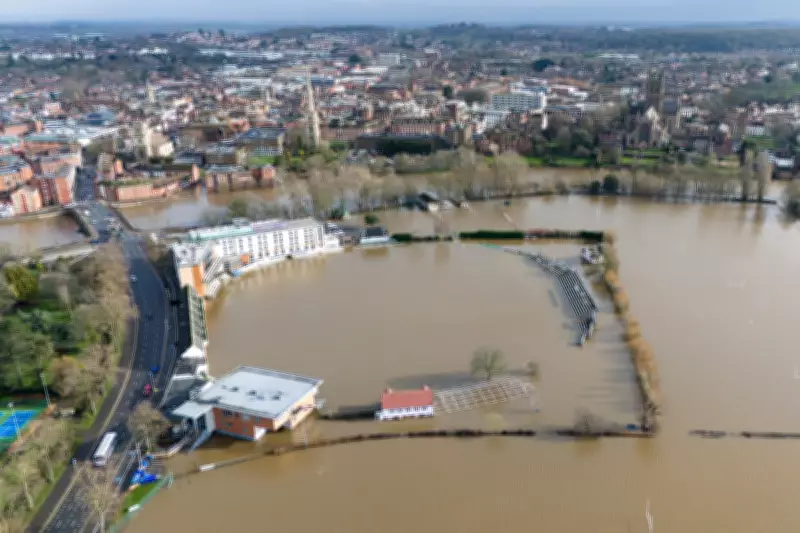
Regional Impact and Record Rainfall
Specific regions have been particularly hard-hit by the continuous rainfall. Parts of Devon, Cornwall, Worcester, Somerset, and West Sussex have now recorded more than 30 consecutive days of rain, according to Met Office data. Locations such as North Wyke in Devon, Cardinham in Cornwall, and Astwood Bank in Worcester have experienced rainfall every single day of the year so far, underscoring the severity of the situation.
A yellow weather warning for heavy rain and potential flooding is currently in effect for Monday across much of south-west England and south Wales. Forecasters predict that 10-15mm of rain will fall widely in these areas, with exposed regions possibly seeing up to 20-30mm. This persistent precipitation is expected to lead to ongoing flooding and significant travel disruption throughout southern England and Wales.
Additional Warnings for Scotland
The adverse weather is not confined to England and Wales. A separate yellow warning for heavy rain and flooding will be active across a large portion of Scotland, stretching from Perth to Aberdeen, from 9am on Tuesday until the end of Wednesday. This expansion of warnings indicates that the unsettled conditions are affecting a broad swathe of the country, increasing the overall risk of flooding and related hazards.
Safety Advice for Drivers
With the increased risk of aquaplaning—where a layer of water causes tyres to lose grip on the road—road safety experts are urging caution. Caitlin Taylor, road safety manager at the Royal Society for the Prevention of Accidents, emphasized the dangers, stating, "Driving in wet weather can be challenging and hazardous, especially when aquaplaning occurs. It is essential that drivers understand the risks and take the necessary steps to prevent aquaplaning, ensuring safer journeys for everyone."
The charity advises drivers to remain calm if aquaplaning happens, recommending they ease off the accelerator and avoid sudden braking or sharp steering to regain control. This guidance is crucial as the continued rainfall heightens the likelihood of such incidents on already saturated roads.
The combination of existing flood warnings, record-breaking rainfall, and forecasts for more wet weather paints a concerning picture for the UK. Residents in affected areas are advised to stay updated with the latest warnings from the Met Office and Environment Agency, and to exercise extreme caution when travelling.


