
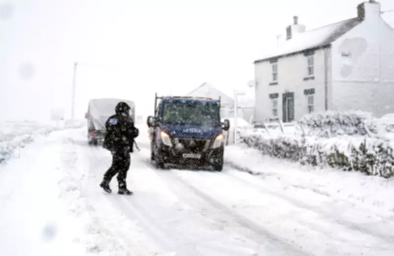
UK Weather Warnings for Snow and Ice in Place as Met Office Says Travel Disruption Likely
The Met Office has issued yellow weather warnings for snow and ice across various regions of the United Kingdom, urging the public to exercise caution due to the heightened risk of travel disruptions and hazardous conditions. Forecasters have specifically highlighted the potential for icy roads and snow showers, which could lead to delays and safety concerns for both drivers and pedestrians.
Warnings and Affected Areas
A yellow weather warning for snow and ice is currently active for Scotland, effective from 4pm on Thursday until midday on Friday. This alert cautions that snow showers and treacherous icy surfaces may result in travel delays and an increased risk of slips and falls for those on foot. In northern England, a similar warning has been issued, spanning from 7pm on Thursday until midday on Friday, with outbreaks of rain, sleet, and snow expected to contribute to icy conditions and possible travel disruption.
Forecaster Marco Petagna provided insights into the weather patterns, stating, "We've got colder air starting to feed in from the north and that's gradually going to push its way south across all parts for the next 24 hours or so. As the air sinks down from the north, we're going to see outbreaks of rain, with some snow mainly on the hills, although across parts of Scotland, it's quite low levels, as things turn a bit more showery tonight."

Snow Accumulations and Forecast Details
The Met Office forecasts that by Friday morning, low-lying areas could see accumulations of 1-2cm of snow, while hills above 300 metres (984ft) might experience 2-5cm, with up to 10cm possible in very localized spots. This Arctic Maritime air mass is bringing colder conditions from northern Scotland southwards, leading to concerns about icy surfaces and potential travel issues.
In the south of the UK, the weather is expected to remain cloudy and wet on Friday, but conditions are likely to clear later in the day. Despite the current warnings, Mr. Petagna offered a glimpse of better weather ahead, noting that Saturday will probably be "the best day we've seen for some time" with "a lot of sunshine across the UK." He added that temperatures will be "cooler than average" but this will be "offset by the sunshine."
Safety Advice and Precautions
The forecaster emphasized the need for vigilance, advising the public to be wary of ice and snow, particularly when traveling. Potential disruptions to transport networks are anticipated, and pedestrians are urged to take extra care to avoid slips and falls on icy surfaces. The Met Office also warns of widespread frost expected on Friday night, which could further exacerbate hazardous conditions.
As the UK navigates this period of colder weather, residents are encouraged to stay updated with the latest forecasts and heed any travel advisories to ensure safety during the snow and ice warnings.


