
Snow Maps Reveal Storm Will Bury Millions of Brits with Several Inches This Week
Major cities including London and Birmingham look set for substantial snowfall this week as advanced weather forecasting maps suggest a widespread blizzard could bring several inches of accumulation to numerous regions across the United Kingdom.
Nationwide Snow Event Predicted for Sunday
Several inches of snow could fall before the end of this week as sophisticated weather models indicate a significant blizzard system is approaching the UK. The GFS weather model specifically shows snow sweeping across the entire nation on Sunday, potentially affecting almost every region of England, Wales, Scotland and Northern Ireland.
Major metropolitan areas including London, Birmingham, Cardiff, Manchester, Newcastle, Belfast and Edinburgh all appear to be directly in the storm's path, according to the latest meteorological projections. This represents one of the most widespread snow events predicted for the UK this winter season.

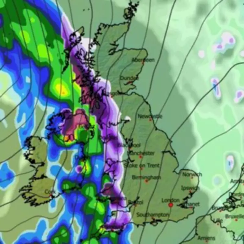
Timeline of the Approaching Snowstorm
Initial flurries are first expected to develop in Northern Ireland and western regions at approximately 3am on Sunday morning. The snow is then forecast to drift steadily eastwards throughout the day, intensifying as it moves across the country.
By around 6am, weather maps indicate heavy snowfall developing across all of Wales, most of Scotland, the north-west of England, the West Midlands region, and even some southern parts of England. The meteorological data suggests the precipitation will continue to spread throughout the morning hours.
By midday, flurries are expected to reach London as well as Yorkshire and the north-east of England. The data indicates the most intense snowfall will be occurring over the Southampton area around this time, potentially creating challenging travel conditions across southern coastal regions.
Snow Accumulation and Coverage Predictions
The weather front is tracked to move off into the North Sea from approximately 6pm, with snow passing over East Anglia during this transition period. By the end of the day, snow could be settled on the ground across roughly 90 percent of the country according to current projections.
Snow coverage maps indicate only the south-west of England, isolated parts of Wales and limited areas of Northern Ireland will likely avoid significant snow accumulation on the ground. Snow depth charts suggest as much as 21cm (eight inches) could settle over hills in Scotland, with 14cm (six inches) possible in northern parts of England.
The Midlands and parts of Wales could see approximately 5cm (two inches) of accumulation, while other regions may experience varying amounts depending on elevation and local conditions. These predictions represent significant potential disruption to transportation networks and daily activities across the nation.
Official Weather Service Forecasts
The Met Office has indicated that "colder conditions" could impact some parts of the UK later this month. Their extended forecast for February 14 to 23 states: "After a briefly quieter spell, associated with some colder conditions, Atlantic frontal zones look to make a return near the start of this period."
The meteorological service further explains: "The track of these depressions may be a little further north than over the preceding weeks, but will continue to bring broadly unsettled weather to many areas, with further spells of rain and perhaps strong winds at times."
Regarding temperature patterns, the Met Office adds: "With the westerly influence, it should become somewhat milder for many, though there remains the chance that colder conditions could affect northern and northeastern parts from time to time."
Additional Meteorological Perspectives
BBC Weather's forecast for next week provides additional context: "The week may start cold with some wintry showers, but atmospheric patterns could shift again. High pressure to the north will most probably weaken and even be replaced by low pressure developing near Iceland by the end of the week."
The broadcaster's meteorological team continues: "That should allow south-westerly wind flows to develop at times, bringing milder air across the UK, although Scotland may still be chillier with temperatures close to seasonal values."

Regarding precipitation patterns, BBC Weather notes: "Inevitably, this more Atlantic-driven regime will bring periods of wet and windy weather as frontal systems cross the UK, and above-average rainfall amounts are expected. This could exacerbate local flooding issues in parts of south-western UK in particular."
The forecast concludes with important winter weather considerations: "There could be snow on the colder leading edge of these rain bands, especially over higher ground in northern areas. Brighter interludes could be just chilly enough for wintry showers on hills elsewhere."


