
England and Wales are poised to experience temperatures exceeding those of popular European holiday destinations like Zante, as meteorological models predict a significant heat surge in early March. Weather forecasting maps have turned a deep red, indicating a dramatic spike in temperatures that could bring unseasonable warmth to much of the United Kingdom.
Heat Blast Details and Projected Highs
According to the ECMWF weather model, temperatures are expected to rise well above the seasonal average, potentially reaching the high-teens. This warm spell is forecast to provide a much-needed respite from the winter chill, affecting nearly every region of the country.
Specific Temperature Predictions for March 6
At 6pm on March 6, maps indicate that the mercury could climb to 17°C in the south-east, Gloucestershire, and parts of South Wales. More broadly, temperatures of 16°C are anticipated across southern, central, and eastern England, with even some areas of Scotland experiencing similar warmth. The north-west of England is projected to peak at 15°C, while Northern Ireland may see highs of 14°C.

Comparison with European Hotspots
In a striking contrast, BBC Weather forecasts that Zante, a Greek party island, will only reach 16°C on both March 6 and March 7. This suggests that parts of England and Wales could be up to 1°C warmer than this Mediterranean destination over the same period, highlighting the unusual nature of this UK heat event.
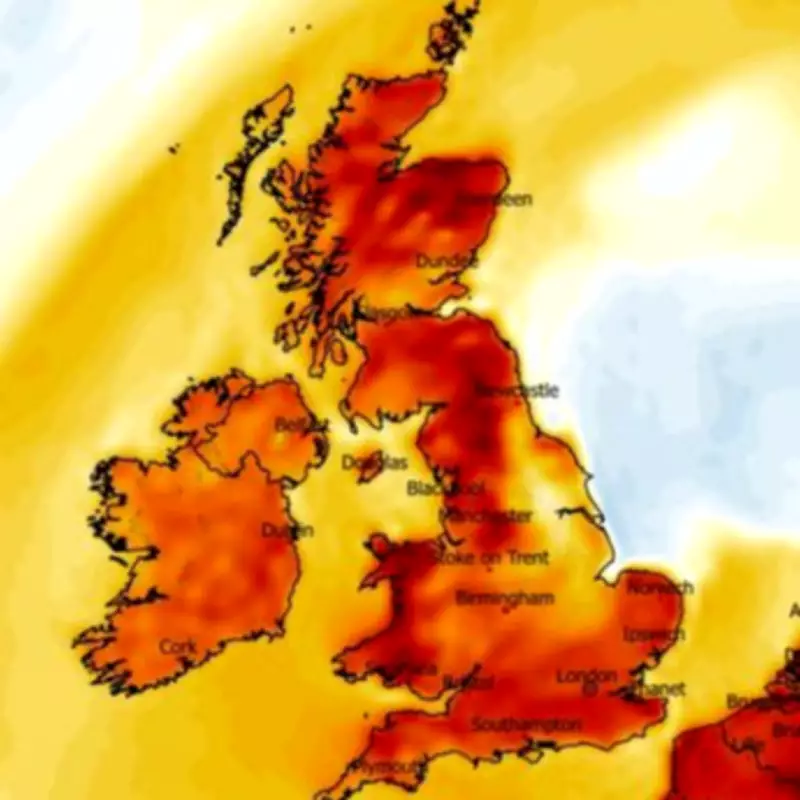
Extended Warmth and Meteorological Insights
Temperature anomaly maps for March 6 show several areas shaded in deep red, signifying temperatures far higher than the norm for this time of year. Similar patterns are expected to persist on March 7, with maximum possible temperature maps again indicating potential highs of 17°C, particularly in central and southern England. However, Scotland, northern England, and Northern Ireland are likely to be slightly cooler compared to the previous day.
Met Office Outlook and Caveats
The Met Office supports the prediction of above-average temperatures at the start of March but also warns of variable conditions. Their forecast for March 1 to March 10 describes changeable weather, with Atlantic frontal systems bringing rain interspersed with drier, brighter intervals. Rainfall is expected to be heaviest in the northwest, while the southeast may remain largely fine.
Additionally, the Met Office notes that some high ground in the north could see snow at times, and winds may be strong with a risk of gales. Despite these mixed conditions, temperatures are likely to be near or slightly above average, reinforcing the overall trend of unseasonable warmth.
Implications and Broader Context
This heat blast represents a notable deviation from typical early March weather in the UK, where average temperatures are usually cooler. The phenomenon underscores the dynamic and sometimes unpredictable nature of British weather patterns, as models continue to refine their predictions in the lead-up to the event.
Residents and visitors alike should prepare for a brief but significant warm spell, while remaining aware of the potential for rain and wind in certain regions. As the dates approach, further updates from meteorological agencies will provide more precise details on this anticipated temperature surge.


