
UK Set to Surpass Ibiza in Temperature as 20C Heatwave Looms
Weather models are indicating that the United Kingdom could experience temperatures soaring as high as 20 degrees Celsius this Wednesday, potentially making it warmer than popular holiday destinations like Ibiza. This surge in heat is forecasted to mark the hottest day of the year so far, with significant implications for spring weather patterns across the nation.
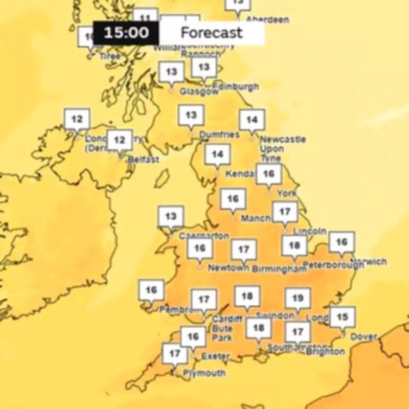
Detailed Temperature Forecasts and Regional Variations
According to the latest maps from the Met Office, temperatures are expected to peak at around 19 degrees Celsius in London at approximately 3 pm on Wednesday. Southern and central England are likely to see widespread highs of 18 degrees Celsius, while Wales and northern regions may experience temperatures between 16 and 17 degrees Celsius. In contrast, Northern Ireland and Scotland are predicted to be slightly cooler, with a few notches lower on the thermometer.
The current record for the warmest day of the year was set on March 5, when London reached 19.2 degrees Celsius. However, some advanced weather models suggest that this record could be broken on Wednesday. Specifically, the UKV model projects possible highs of 20 degrees Celsius in south-east England around 3 pm, with eastern areas, the Midlands, and broader southern regions expecting temperatures of 19 and 18 degrees Celsius.

Comparison with International Destinations and Seasonal Anomalies
In a striking comparison, the Met Office forecasts that Ibiza will only see temperatures peaking at 16 degrees Celsius on Wednesday, with Zante expecting highs of just 15 degrees Celsius. This means the UK could outshine these Mediterranean hotspots, offering a rare warmth for this time of year.
The GFS weather model further supports this trend, indicating that temperatures will spike well above the seasonal average on Wednesday. Temperature anomaly maps for around 6 pm reveal deep red areas across England and Wales, signifying regions that will be much warmer than typically expected for mid-March. This anomaly highlights the unusual nature of the impending heatwave.
Extended Forecast and Weather Patterns Beyond Wednesday
Looking beyond Wednesday, the Met Office predicts that the UK will experience frequent spells of pleasant spring sunshine. However, there is also a risk of some colder interludes. The forecast for March 19 to 28 states that conditions will quickly turn more settled, with most places remaining predominantly dry. Temperatures are expected to fluctuate between milder and colder than average, potentially leading to overnight frost and fog. Despite this, daytime conditions should feature regular sunny spells, making it feel fine away from coastal areas exposed to brisk easterly winds.
The longevity of these settled conditions remains uncertain, with some signals suggesting that showers or rain could return later in the period. BBC Weather adds that more rain may arrive from the Atlantic on Monday, but high pressure building over the near continent could keep much of it away from southern areas, especially the Southeast. High pressure is then expected to dominate through the rest of the week.
On Tuesday, further rain and strong winds are possible in some northern and western areas, while much of the country enjoys a breezy but drier and warmer day with some sunshine. From Wednesday onwards, high pressure near or over the UK should ensure plenty of dry weather. Some fairly cold and foggy nights are anticipated, but by day, warm sunshine is forecasted for most places. However, easterly breezes could develop, making eastern coastal regions feel chillier at times.
This weather event underscores the dynamic nature of UK climate, with rapid shifts between warmth and cooler spells as spring progresses.


