
The Met Office has announced that the United Kingdom is poised to experience temperatures soaring to a remarkable 20 degrees Celsius on Wednesday, potentially marking the hottest day of the year so far. This unexpected warmth will see parts of the UK outshine popular Mediterranean holiday hotspots, including the Greek island of Zante.
Unseasonal Heatwave Brings Record-Breaking Temperatures
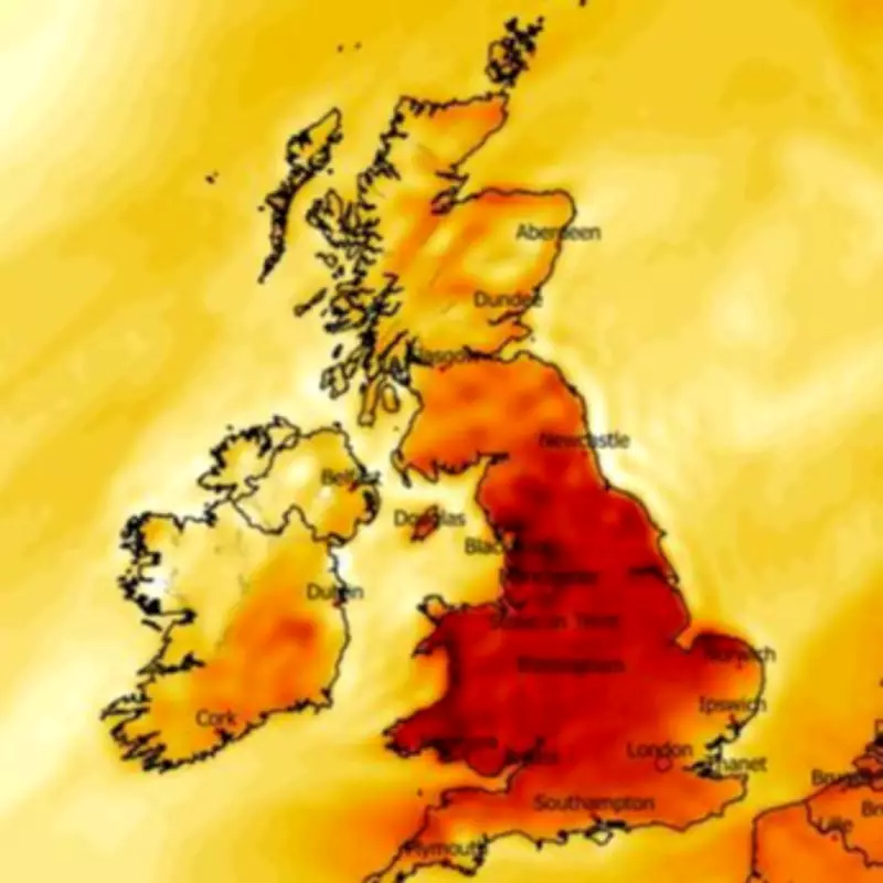
According to the national weather agency, sunshine is expected to develop across southern and western regions today, leading to a significant rise in temperatures. Some areas could reach 17C this afternoon, with even warmer conditions anticipated for tomorrow. Temperature anomaly maps reveal extensive areas of England and Wales shaded in deep red for Wednesday afternoon, indicating where temperatures are predicted to climb well above the seasonal average.
Met Office Chief Forecaster Details the Warmest Spots
Met Office chief forecaster Dan Harris confirmed that Wednesday will be the warmest day of the week and could set a new record for 2026. He explained that as high pressure becomes dominant, western parts of Wales and England are likely to experience the highest temperatures. "The warmest spots are likely to be in parts of west Wales and western England, where under sunny skies, 18-19C, possibly even 20C is on the cards," Harris stated.

He attributed this surge to the Foehn effect, where east to south-easterly winds passing over higher ground provide an additional boost to temperatures. The current temperature record for this year stands at 19.2C, recorded in London on March 5, meaning Wednesday's forecast could easily surpass this milestone.
UK Outperforms Mediterranean Destinations
While the UK braces for potential 20C heat, destinations like Zante in Greece are only expected to see highs of around 16C. Similarly, Ibiza in Spain is forecast to experience similar temperatures, making the UK comparatively warmer for a brief period. This anomaly highlights the unusual nature of this weather pattern, which is bringing spring-like conditions earlier than typical seasonal averages.
Cooling Trend Expected Later in the Week
The Met Office indicates that conditions will start to cool on Thursday, although anomaly maps still show some areas enjoying above-average temperatures. By Friday, the mercury is expected to return to around the seasonal average, bringing an end to this temporary heat spike.
BBC Weather adds further detail, noting that tomorrow will bring sunshine for most, with only the odd shower in far north-western Scotland. Southern Scotland, Northern Ireland, and Cumbria will be mostly cloudy with occasional light rain. The forecast for Thursday, Friday, and Saturday predicts largely dry and settled weather as high pressure takes control, featuring sunny spells, variable cloud cover, and some overnight fog. Winds will be light or gentle throughout, with a trend toward less mild conditions from Friday onwards.
This weather event serves as a reminder of the variability in UK climate, with such warm spells occurring unexpectedly even in early spring. Residents are advised to make the most of the sunny conditions while they last, as cooler temperatures are on the horizon.


