
Advanced meteorological models are predicting a significant temperature surge across the United Kingdom this week, with parts of England expected to become warmer than popular European holiday destinations. According to the latest data from the ECMWF weather model, a notable heat spike could see temperatures reach as high as 18 degrees Celsius in some regions, marking a dramatic shift from the recent weeks of dismal conditions.
Unseasonable Warmth Across Southern England
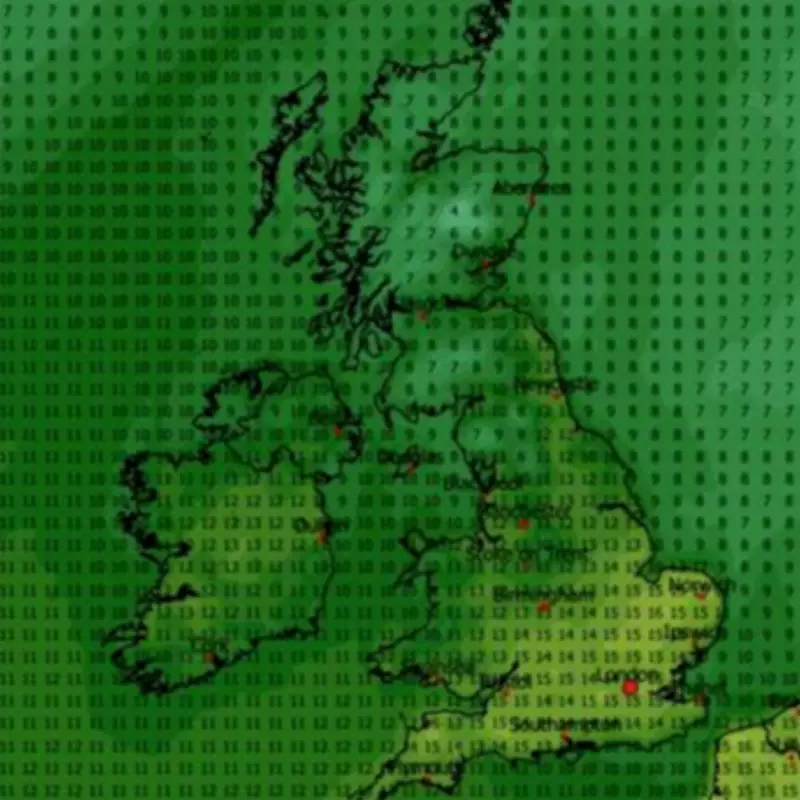
The weather maps reveal that maximum possible temperatures of up to 15C are forecast for southern England, the Midlands, and East Anglia around midday. Major cities including Norwich, London, and Southampton are all set to experience unseasonably warm conditions, providing a welcome respite from the typical February chill.
Regional Variations in Temperature
While southern areas bask in the warmth, other regions will see more moderate increases. Wales and northern England could experience highs of around 13C at midday, with Northern Ireland potentially reaching 11C. Scotland is expected to remain cooler, with temperatures struggling to climb into double digits in most areas, highlighting the diverse climatic patterns across the UK.

By 6pm, the eastern parts of England might see temperatures peak at 18C, with the south, Midlands, and sections of Wales recording highs between 16C and 17C. This spike places the UK in a favorable position compared to European hotspots; for instance, Barcelona is forecast to hit only 16C on Wednesday, while Athens is expected to reach just 15C.
Temperature Anomalies and Seasonal Comparisons
Temperature anomaly maps for Wednesday indicate that mercury levels will rise well above the seasonal average. Areas depicted in deep red on the maps show where temperatures will be highest relative to the norm for this time of year, underscoring the unusual nature of this warm spell.
Met Office Forecast and Outlook
The Met Office has echoed these predictions, suggesting "pleasant" conditions are on the horizon for the week. Their forecast for Wednesday to Friday notes rain in the north and west on Wednesday, with drier conditions and sunny spells in the southeast. However, wetter and windier weather is expected to return for all on Thursday, followed by cooler temperatures with sunshine and showers on Friday.
Looking further ahead from February 28 to March 9, the Met Office anticipates changeable conditions, with Atlantic frontal systems moving across the UK interspersed with drier and brighter intervals. Rainfall is likely to be heaviest in the northwest, with sheltered eastern areas receiving much less. There is also a possibility of snow across high ground in the north.
As the period progresses, drier and more settled weather may become more prolonged, especially in the east. Winds are expected to be strong at times, with a risk of gales, while temperatures are projected to be near or slightly above average, continuing the trend of mild conditions.


