
Millions Under Threat as Vast Storm System Sweeps Across United States
A massive and dangerous storm system is raging across the southern and eastern United States, placing millions of Americans under tornado watches and warnings. The National Weather Service's Storm Prediction Center has issued a high risk alert for tornado formation across nine states, affecting over 12 million people as of Sunday evening.
Severe Tornado Risk and Widespread Damage Potential
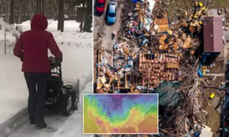
Meteorologists have identified Arkansas, Missouri, Mississippi, and Tennessee as facing the highest risk of tornado development, with additional threats extending into Illinois, Indiana, Ohio, Kentucky, and Georgia. Some of these potential tornadoes are forecast to reach EF2-level intensity on the Enhanced Fujita Scale, capable of generating wind gusts between 111 and 135 miles per hour.
Such powerful tornadoes can tear roofs from houses, snap trees in half, and lift vehicles into the air. The storm system draws moisture from both the Pacific Ocean and the Gulf of Mexico, creating volatile conditions with a dangerous mix of rain, high winds, and rapidly changing temperatures.

Travel Chaos and Flight Disruptions Mount
Major travel disruptions have already emerged across the Midwest, with thousands of flights delayed or canceled at key transportation hubs. At Chicago's O'Hare and Midway International Airports, more than 850 flights have been canceled, while Minneapolis-Saint Paul International Airport has seen over 600 cancellations.
Meteorologists warn that flight delays and cancellations could increase through Monday night, with ripple effects expected to spread across major hubs including Chicago, Detroit, Atlanta, New York, Boston, Washington DC, and Philadelphia.
Heavy Snowfall and Extreme Winter Conditions
The northern portion of the storm has already dumped more than a foot of snow across parts of southern Minnesota and central Wisconsin, with additional accumulation expected through Monday. Rochester, Minnesota has recorded a foot of snowfall already, with predictions of up to another foot before the storm subsides.
Parts of Michigan's northern peninsula could receive up to three feet of snow by Monday night, while the city of Marquette may experience record-breaking snowfall of up to four feet. Minnesota Governor Tim Walz has activated the National Guard through an executive order to assist with emergency operations as the storm intensifies.
Personal Accounts and Emergency Responses
Instagram influencer Sarah Krafft shared a dramatic video from Mississippi showing the storm approaching her home with ominous, dark clouds forming on the horizon. 'Today we're under a tornado warning and a wind advisory with hurricane-like winds,' Krafft reported. 'When I looked at the radar coming up, it looks like a bright red line coming right for us.'
Krafft and her husband evacuated to his parents' house to escape the tornado warning path, noting that temperatures had plummeted to 15 degrees Fahrenheit. In Maryland's Baltimore County, all public schools and their offices will close early on Monday due to storm and tornado risks, according to a school district announcement.
Expanding Threat and Meteorological Perspective
As the storm moves eastward on Monday, the highest risk of tornadoes and severe thunderstorms will shift to parts of Maryland, Virginia, North Carolina, and South Carolina. A level four out of five risk for severe thunderstorms has been issued for Monday from the Carolinas to the Maryland-Pennsylvania border, with surrounding areas under a level three risk.
The storm's wind gusts have already reached 75 miles per hour in some southern areas, leaving hundreds of thousands without power. Bob Oravec, a senior forecaster at the National Weather Service's Weather Prediction Center, captured the extraordinary nature of the weather event, remarking, 'All of a sudden, Mother Nature is having a fit.'
This widespread weather system continues to pose significant threats across multiple regions, combining tornado risks, severe thunderstorms, heavy snowfall, and major travel disruptions in an unusually intense early spring weather event.


