‘A noisy river is a healthy river,’ says Ruth Needham of the Trent Rivers Trust (TRT). The Mease in the Midlands must be in fine fettle, then, as it gurgles merrily along. Sunlight glints off riffles in the water and shoals of fry dart past. Needham whips out her phone to video the tiny fish: ‘My colleagues will be jumping for joy to see them!’
Needham has good reason to be buoyant. Last month, the Mease won the UK River prize 2026 – which was established by the River Restoration Centre in 2014 to acknowledge innovative projects – in recognition of the trust’s 13-year restoration campaign. ‘The prize has been a massive boost,’ says Needham. ‘If we can get the Mease into better condition, we can improve other rivers, too.’
From Straitjacketed to Restored
The sad state of Britain’s rivers is common knowledge, partly thanks to the recent Channel 4 drama Dirty Business, which made the sewage crisis headline news. And pollution is not the only problem. While many people think of rivers as natural features of the landscape, they have been altered almost beyond recognition by human hands: straightened, strengthened, deepened and sped up. This has had catastrophic consequences.

The Mease is a case in point. The 27km lowland river rises in Leicestershire, passes through south Derbyshire and Staffordshire, and flows into the River Trent at Croxall. Farms dot its banks; there are more than 400 farmers in its catchment area. Food production has long been the priority in this region, the river an inconvenience to be controlled and corralled – or ‘straitjacketed’, in Needham’s words. ‘For too long, water has been seen as a problem: drain it, dredge it, get it away,’ she says.
Giving Water Space
Rivers aren’t a single straight trench of water like a canal. They meander, merge with other waterways and often overflow their banks, running into natural channels. ‘Water needs space,’ says Needham. The wet land around rivers is paradise for wildlife but purgatory for farmers, unpredictable and unproductive.
So, over the past 150 years, drainage ditches have been engineered along the Mease, its banks shored up, its flow controlled with weirs. This meant excess water was no longer diffused across the floodplain. ‘A lack of connectivity between river and floodplain is seen across the board in lowland agricultural areas,’ says Needham. ‘We’ve been draining our land for 150 years – we’ve got too good at it. It drains so well that you get flood peaks downriver, causing a massive problem for villages. Climate change is only making it worse.’
Soil, silt and sediment got washed from the fields straight into the river. The resulting high levels of phosphate caused algal bloom, stopping light getting in and decreasing oxygen levels. ‘The fish really struggled,’ says Needham. That includes two rare species that make the Mease a designated site of special scientific interest (SSSI): the spined loach and European bullhead. Other wildlife declined too, as there were no natural water channels with a mix of habitats to support different species. ‘The state of the river was no longer acceptable,’ says Needham.
Building Trust with Farmers
In 2013, a restoration project began, led by the TRT and largely funded by the Environment Agency (EA). ‘We wanted to change the status quo, force the issue and get people to work together,’ Needham says. Perhaps the biggest challenge was to get farmers on board. They were effectively being asked to give up land: instead of farming right up to the riverbank, they would have to leave buffer strips for water and wildlife. It took time to build trust – and to apply for compensation under the government’s environmental land management schemes.
So far, 111 farmers have got on board, covering just over half of the river’s catchment area. This includes Jo and Tony Thorp, a father and daughter duo who raise dairy cows on the 130-hectare (320 acres) Culloden Farm in Leicestershire, and make their own ice-cream. They worked with the TRT to restore a 500-metre tributary of the Mease that runs through their land. Instead of being diverted into two ditches, the water is now a stream that finds its own slow path across the field. It traps pollutants before they enter the river, then forms a wetland area to attract birds such as the threatened sedge warbler.

I visit on a bright spring day with Adam Noon, a catchment coordinator from the EA. The stream was only established last year but already we can see algae growing where phosphates and nitrates have been trapped, and see the wetland area bursting with life. Noon reels off birds as he spots them: little ringed plover, reed bunting, yellowhammer, green woodpecker. He has previously seen lapwing and golden plover, both species that need wet ground. ‘Slow the flow, get the habitat right and the species will come,’ he says. Right on cue, we spot two hares.
Creating a Mosaic of Habitats
The farm is one of eight flagship restoration sites along the Mease. Another is at the confluence of the Mease and the Gilwiskaw brook, where 2.5 hectares (6 acres) of formerly marginal farmland is now another wetland, home to snipe and lapwing. ‘We’re creating a mosaic of habitats – jewels linked by long watercourses,’ says Needham. ‘It’s a nature-based recovery; we’re just prompting it.’
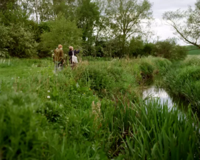
I stroll along the footpath and new bridges with Jan Cope and Liane Coleman, two volunteers who are usually knee-deep in the river in their waders, yanking out invasive Himalayan balsam from the banks. Volunteers have cleared more than 12km of balsam, which outcompetes native plants such as water-crowfoot and can cause erosion problems. Today, Cope is busy pulling out rogue plants that survived her last patrol.
Volunteers have played a key role in the restoration, funded by Severn Trent. Cope and Coleman have been trained in riverfly monitoring, too – stoneflies, caddisflies and mayflies are very sensitive to pollution, so their presence is a good indicator of water quality. So far, numbers are increasing at several sites.
Scaling Up the Success
In all, 17km of the river has been restored and 25 hectares (60 acres) of new habitat created. The TRT has made about 250 interventions, including creating silt traps, wetlands and buffer strips to trap pollution, and making bunds (dykes), leaky barriers, swales and ponds for flood management. All this doesn’t come cheap: the EA has invested more than £1.6m in the catchment since 2017. More than £800,000 has come from developers; in excess of £120,000 from Natural England; and about £80,000 from Leicestershire county council.
Separately, Severn Trent is spending more than £100m to reduce storm sewer overflow at 17 sites across the catchment, and is building a controversial new 24km pipeline, which means treated sewage will bypass the Mease and enter the River Tame. In a letter to affected residents last month, the water company said: ‘The River Mease currently has a flow that’s about twice as high as it should be naturally, and part of this is because of the amount of cleaned used water going into it from our works. To help bring the Mease back to its natural condition, we’re going to take the outflow from these plants and send it through a 24km pipeline we’re installing across to the Tame. At the same time, we’re going to be upgrading the two treatment works to further improve water quality.’
The Mease is classified as a special area of conservation (SAC) as well as an SSSI; the Tame is not. Suffice to say, the pipeline plan is not popular with lots of local people and raises the concern that as water quality improves in some rivers – such as at the 13 new bathing sites across England announced last week – others will get worse.
On the Mease, meanwhile, the work isn’t over. About 30 additional restoration schemes are in the planning stages. More needs to be done to support fish, for example. So far, gravel has been added to the riverbed to create areas for them to spawn, wood added and fallen trees left in place to create feeding grounds for juvenile fish, and saplings planted to provide them with shelter. Judging by the teeming fry we saw at the confluence, it is working. But there is still one remaining weir causing a barrier to migration. This summer, a channel will be built to bypass it. This strategy has already been implemented on the Trent, where the Colwick fish pass was installed in 2024 to open up the river for salmon, trout and eels.
The Mease is a small river, and can access funding thanks to its SAC and SSSI status. Can this kind of restoration really be replicated nationwide? ‘If we can get it right on the Mease, we can do it everywhere else,’ insists Needham. ‘We can scale up.’ She concedes that river restoration is hampered by a lack of national funding, however, and is anxiously awaiting the outcome of January’s water white paper.
I ask her how Britain’s rivers compare with the rest of the world. ‘They’re pretty shocking,’ she says. ‘We really haven’t looked after our rivers at all well, thanks to a combination of engineering, pollution and neglect.’ However, she thinks attitudes have finally changed, and is optimistic for the future. ‘In 20 years, we’ll see more natural spaces along our rivers.’
Ultimately, she says, the restoration of the Mease has shown the importance of working together: government, campaigners, farmers, volunteers. ‘We all want our rivers to be protected,’ she says. ‘We have ignored them for too long.’