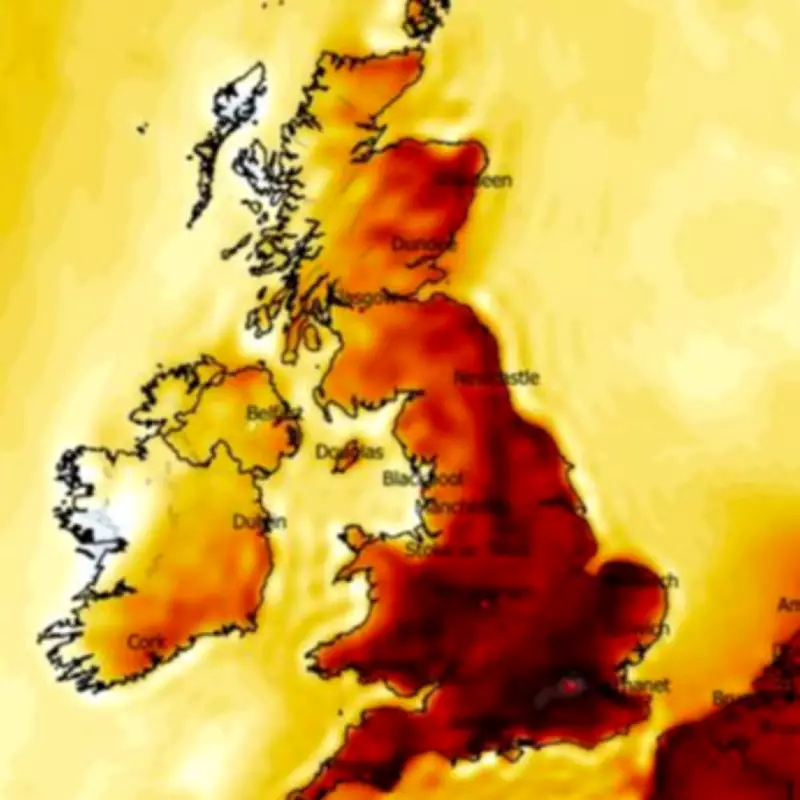
The United Kingdom has officially recorded its hottest day of the year so far, with the Met Office confirming temperatures soared to a remarkable 26.5°C at Kew Gardens today. This marks a significant milestone for 2026, surpassing the previous high of 24.8°C set in Mona, Anglesey, just yesterday. The unseasonably warm conditions are attributed to a surge of warm air moving northwards from continental Europe, providing Britons with a taste of late spring or early summer weather in early April.
Sudden Shift in Weather Patterns
However, this brief spell of balmy weather is set to be short-lived, as meteorological models indicate a dramatic and rapid change is on the horizon. Weather maps from the European Centre for Medium-Range Weather Forecasts (ECMWF) reveal that snow is expected to hit parts of Scotland as early as the overnight hours into Saturday, with flurries potentially spreading across northern England over the weekend.
Detailed Snowfall Predictions
The forecast suggests that low pressure systems moving in from the Atlantic will combine with cold Arctic air, bringing not only snow but also rain further south on Saturday. Specific predictions include several centimetres of snow accumulation in central and western Scotland, as well as in Cumbria in northern England. By Monday, the snow is projected to extend its reach, with patches appearing in central England, Wales, Northern Ireland, and the south-west regions.

Temperatures are anticipated to plummet sharply over the weekend, dropping into single figures and continuing this cold blast into the middle of next week. This represents a stark contrast to today's highs, with some areas potentially experiencing a temperature drop of around 10°C between Wednesday and Thursday.
Expert Analysis and Warnings
Met Office Chief Forecaster Paul Gundersen commented on the unusual weather patterns, stating, "We’re seeing a brief but notable spell of very warm weather for early April, with temperatures more typically associated with late spring or early summer. This could be the warmest spell at this point in April since 2020." He further warned, "However, this warmth will be short-lived, with a marked drop in temperatures and more unsettled conditions developing later this week."
The BBC Weather forecast aligns with this outlook, predicting unsettled conditions from Friday through Sunday. On Friday, eastern and southern areas may enjoy mostly dry weather with sunny spells, while other regions will turn windy and cloudy with rain and showers. Saturday will see a band of cloud and light rain across northern and central areas initially, with rain moving eastwards and intensifying later, though western areas could turn drier and sunnier. Sunday is expected to bring a few scattered showers, with overall less warm conditions prevailing.
This weather shift comes after the UK recently experienced an Arctic blast brought by Storm Dave last week, which led to yellow alerts for snow and wind over the weekend. The rapid transition from record-breaking warmth to impending snowfall underscores the volatile and unpredictable nature of early spring weather in the region.