
Storm Chandra has unleashed a wave of severe weather across the United Kingdom this week, bringing powerful winds, torrential rain, and snowfall that has disrupted communities and infrastructure. The Met Office has responded by issuing a series of yellow weather warnings, with the situation evolving rapidly.
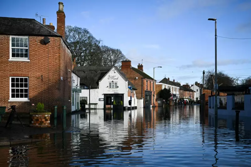
Major Flood Incident Declared in Somerset
A significant flooding event in Somerset led to the declaration of a major incident on Tuesday. Somerset Council, in coordination with the Environment Agency and emergency services, mobilised resources to assist communities severely impacted by overnight heavy rainfall and extensive flooding. The storm set several new January daily rainfall records, exacerbating the crisis.
Widespread Travel Chaos and School Closures
The adverse conditions caused considerable travel disruption. Dozens of flights were cancelled across Scotland and Northern Ireland due to the strong winds associated with Storm Chandra. On the ground, horrendous flooding trapped numerous vehicles, forced road closures, and led to several school closures. In a serious incident in Lisbellaw, a woman was hospitalised after a tree fell onto a car on Snowhill Road during the storm on Tuesday morning.

Met Office Issues Ice Warnings Following the Deluge
As the wet weather subsided, a new hazard emerged. The Met Office has issued yellow warnings for ice for Wednesday, covering extensive parts of the UK. Forecasters warn that patchy ice is likely to form overnight across sections of Northern Ireland, England, and Wales as temperatures plummet below freezing.
The national weather service cautions that icy patches on untreated roads, pavements, and cycle paths could lead to injuries from slips and falls. The public is advised to expect longer journey times and potential cancellations affecting road, rail, air, and ferry services, with some roads and bridges likely to remain closed. Driving in these dangerous conditions is not recommended, and forecasters suggest staying indoors where possible to avoid injury from persistent high winds.
Regions Under the Ice Warning
The areas affected by the yellow weather warning for ice on Wednesday are extensive and include:
- Parts of Northern Ireland
- Central England, the East Midlands, and the east of England
- London and South East England
- North East England and North West England
- Parts of Scotland, including Lothian Borders and Strathclyde
- Wales
- West Midlands
- Yorkshire and Humber
The Met Office states that ice forming overnight Tuesday into Wednesday morning may lead to disruption during the early part of the day.
Further Rain Forecast, Raising Flood Risk Again
The respite may be brief. The Met Office predicts further rain on Thursday, which is expected to lead to additional flooding and transport disruption, particularly in southwest England. There is a small chance that fast-flowing or deep floodwater could pose a danger to life.
Forecasters explain that a band of rain is likely to reach southwest England on Thursday afternoon, spreading quickly northeastwards. While the rain may only last a few hours in any one location, it will be heavy at times. An additional 10 to 20 mm of rainfall is expected quite widely, with 20 to 40 mm possible in wetter spots, especially across moorland. This new rainfall will fall onto ground already saturated from Storm Chandra, significantly increasing the flood risk.


