
Nationwide Snow Alert: 12-Hour Blizzard Could Blanket Entire UK
Startling new weather forecasting models indicate that every single region of the United Kingdom could experience significant snowfall this month, as a powerful 12-hour storm system prepares to sweep across the nation. The meteorological data paints a dramatic picture of a widespread blizzard event that would impact major cities and rural areas alike, with some regions facing accumulations exceeding half a metre.
Timeline of the Approaching Winter Storm
According to detailed projections from the GFS weather model, this substantial weather event is currently forecast to begin its assault on February 16, initially bringing snowfall to Northern Ireland, Wales, and south-western England around 3pm. As the afternoon progresses, the storm is predicted to drift eastwards, potentially engulfing England's major metropolitan centres including London, Birmingham, Manchester, and Liverpool by approximately 6pm.
The meteorological maps suggest that Scotland will not escape this wintry onslaught, with parts of the country expected to receive snowfall during the evening hours. By midnight, the data indicates intense snow precipitation covering all of Scotland, placing Glasgow and Edinburgh directly in the storm's path while central and northern England continue to experience further snowfall. The weather front is projected to finally drift over the North Sea around 3am on February 17.

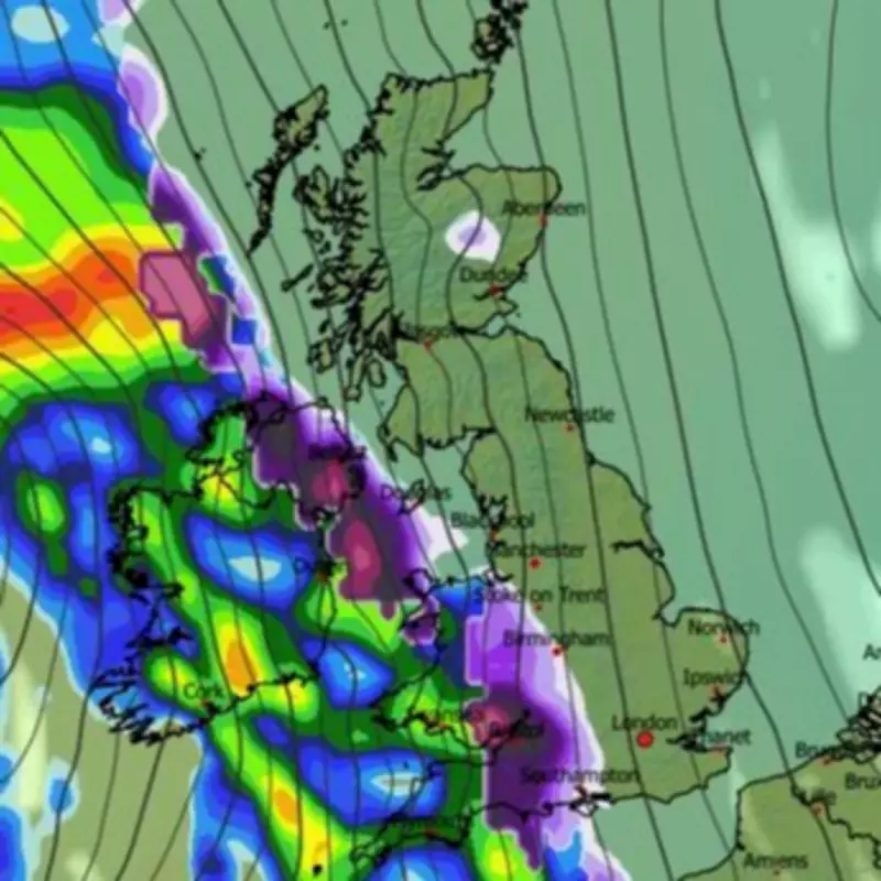
Projected Snow Accumulations Across Regions
Snow coverage visualisations for February 17 show the entire United Kingdom shaded in purple, indicating the potential for settled snow on the ground in every corner of the nation. The most concerning accumulations are forecast for the Scottish Highlands, where snow depth charts suggest a possible 54 centimetres (21 inches) could accumulate, creating potentially hazardous conditions.
Other regions face significant accumulations as well:
- Northern England: Up to 18 centimetres (7 inches) possible
- The Midlands: Approximately 10 centimetres (4 inches) forecast
- Southern England: Around 8 centimetres (3 inches) expected
- Wales: Similar accumulations of about 8 centimetres anticipated
Meteorological Perspectives on February's Weather
The BBC Weather forecast for February 16 to March 1 suggests that despite some temperature improvements in certain areas, further snowfall remains a distinct possibility throughout the month. Their analysis indicates that the middle of February may maintain colder-than-normal conditions across most UK regions, with frontal systems potentially bringing wetter and windier weather from the south-west during the latter half of the month.
BBC meteorologists note that cold air lingering across northern regions could cause rain bands to be preceded by snow, with milder conditions taking longest to reach Scotland. They emphasise considerable uncertainty regarding the timing and speed of any potential temperature increase.
The Met Office's forecast for February 15 to March 1 similarly suggests more snow could affect the UK, particularly noting that a south-shifted jet stream is likely to persist, steering low-pressure systems toward and south of the country. This pattern would bring further spells of wet and windy weather, with rain most frequent in southern, western, and eastern Scotland regions.
Met Office forecasters indicate that some hill snow remains possible as wet weather encounters colder air across northern UK areas, with temperatures for the period expected to be close to average in the southwest but slightly below average in the northeast.


