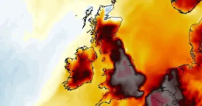

A new heatwave is expected to develop across parts of the UK from this weekend, with forecasters predicting temperatures could climb to 33°C or 34°C. The UK Health Security Agency (UKHSA) has issued yellow heat health alerts covering the East of England, East Midlands, West Midlands, South West, London, and the South East, effective from midday on 4 July until 8pm on 11 July. The hottest conditions are anticipated in southern England.
Duration and Intensity of the Heatwave
Although this heatwave is not forecast to be as intense as the record-breaking spell experienced in June, it is estimated to last considerably longer. For some regions, this will be the third heatwave of the year. Many forecasting models suggest that the hot spell could persist into the middle of July.
Weather maps generated on Saturday, 4 July by WXCharts indicate that Saturday, 11 July might be the hottest day of the month so far. The highest temperatures will be concentrated across southern and eastern England, where values could widely exceed 30°C.

Regional Variations
In contrast, areas on the western side of the UK, including Lancashire, the Lake District, western Scotland, and Northern Ireland, are expected to experience the Atlantic breeze, which will act like a natural air conditioner, limiting temperatures to the low to mid-20s Celsius.
Forecast Details
The forecast suggests that weather will become increasingly warmer from Monday next week, with the heat expected to peak during the second half of the week across England and Wales as high pressure builds from the Azores.
The Met Office, in its own separate long-range forecast from 9 July to 18 July, states: "High pressure will continue to prevail across England and Wales, likely extending its influence into the northern UK for a time. This will continue to bring dry and very warm weather across England and Wales, but there is an outside chance of the odd localised thunderstorms at times."
The Met Office adds: "High pressure may extend northwards to bring periods of drier and warmer weather to most of Scotland and Northern Ireland too. Winds will be light to moderate for most. Temperatures will be widely very warm at first, although not as hot nor humid as seen in June. There are signals for the heatwave to ease back to more normal summer temperatures in the week commencing Monday 13 July."
Areas at Risk of 34°C
According to WXCharts, the following 13 areas have the potential to reach 34°C: Chester, Liverpool, Stoke-on-Trent, Derby, Leicester, Birmingham, Coventry, Peterborough, Ely, Cambridge, Luton, St Albans, and London.