
Fresh snow and ice warnings continue to be enforced across extensive regions of the United Kingdom today, coinciding with major flooding that has already submerged parks and scenic areas. This hazardous weather arrives as millions of families commence their half term holidays, raising significant concerns about travel safety and disruption.
Active Weather Alerts and Flood Risks
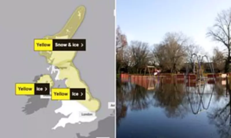
A yellow warning for ice is currently active across parts of the country, with flooding anticipated in more than seventy specific areas. While several snow and ice warnings lapsed over the weekend, a yellow ice alert remains in effect for eastern Scotland and north-east England until 10am on Tuesday. Additionally, a separate yellow ice warning has been issued for vast expanses of England and Scotland, valid from 6pm on Monday until 10am on Tuesday.
Northern Ireland is also experiencing the severe wintry conditions, with a yellow ice warning in force from 8pm on Monday until 10am on Tuesday. The Environment Agency has strongly urged the public to maintain vigilance due to the persistent flood risk, following heavy rainfall that has placed dozens of areas in danger of inundation.

Flood Warnings and Alerts Across England
As of Sunday night, England recorded seventy-four flood warnings, indicating that flooding is expected, alongside one hundred and ninety-five flood alerts, where flooding is possible. This grim meteorological outlook is exacerbated by plummeting temperatures that are forecast to dip below freezing overnight, potentially causing travel chaos for holidaymakers.
Forecasters predict that rain and hill snow will solidify in various UK regions, increasing the risk of perilous black ice and rendering roads treacherous, particularly in eastern Scotland and north-east England. Wintry showers are expected to move southwards on Tuesday and Wednesday, with hill snow likely to impact parts of England and Scotland, sparking fears of further disruption.
Recent Weather Events and Official Statements
This follows a weekend where parts of the UK were blanketed with snow after the Met Office declared freezing conditions, with temperatures dropping as low as minus five degrees Celsius. Jonathan Day, the flood duty manager at the Environment Agency, reported that while more than twenty-four thousand homes and businesses have been protected, approximately three hundred and thirty have been flooded.
The Met Office has cautioned that ice forming on untreated surfaces within the warning areas could lead to difficult travelling conditions. Their warning stated: 'Following a spell of rain and some hill snow during Sunday afternoon, temperatures will fall below freezing as skies clear from the west through the evening and overnight, leading to ice forming on untreated surfaces.'
Expert Forecasts and Safety Advice
Met Office operational meteorologist Dan Stroud highlighted the hazardous conditions, noting the potential for black ice and slippery surfaces in the yellow warning zones and advising people to take extra care. He elaborated: 'Monday really is a day of sunny spells and blustery showers. Overnight Monday into Tuesday we will see a frosty start. It's going to be a largely dry day, with some decent amounts of winter sunshine.'
Stroud added: 'But it does start to go downhill later in the day, from the south and the west we've got a broad area of cloud and rain pushing into south-west England and South Wales late on Tuesday. During the course of Wednesday this will bring a mix of rain, sleet and hill snow. We do need to keep an eye on this system, as there's the potential for snow warnings to be issued.'
Looking further ahead, he indicated that Thursday into Friday will be largely dry with some clear skies, turning milder towards the end of the week. However, the immediate focus remains on the current ice and flood threats as families navigate their half term plans amidst these challenging weather conditions.


