UK Weather Maps Reveal Exact Date for Snow and -4C Freeze
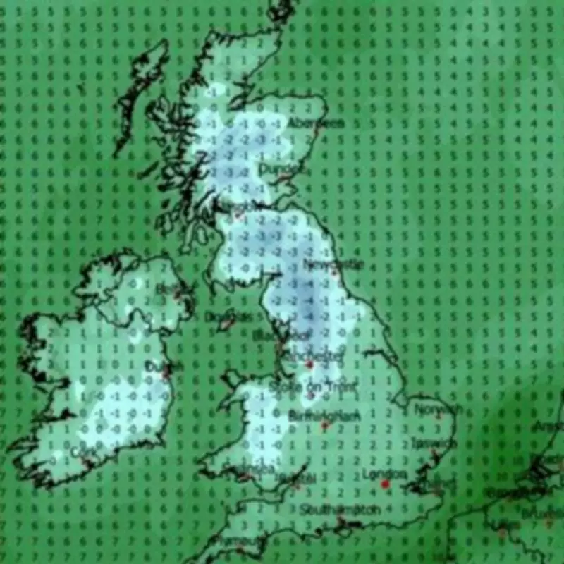
According to detailed weather maps, some Britons could face snowfall and a severe temperature drop, with readings plummeting as low as -4C in certain regions, as early as the coming days. The forecasts, based on MetDesk data visualised by WXCharts, show purple and white hues signalling impending snow, alongside icy blue areas indicating frigid conditions.
Spring Chill Brings Winter-Like Conditions
Despite being midway through spring, the UK has experienced cooler than expected temperatures over the past two weeks. The Met Office has noted the potential for "unsettled conditions" to return towards the end of April, aligning with the WXCharts predictions that April 25 might feel more like a winter day, particularly across Scotland and northern England.
Snowfall is anticipated to commence from midnight on April 25, with maps revealing a substantial purple area, denoting snow, spreading across the Scottish Highlands and covering Aberdeen and the North East. A band of snow is also projected to stretch from the Scottish borders down to Stoke-on-Trent, although it is expected to be lighter across Greater Manchester and Staffordshire.

Temperature Plunge and Persistent Snow
Accompanying the snow, temperatures are forecast to drop below freezing, with predictions reaching as low as -3C in the Highlands and Perth and Cross areas. In North Yorkshire, temperatures could hit a chilling -4C. Minimal temperature variation is expected throughout the day, with the nation ranging between -2C and 4C.
The snowfall is likely to persist well into the evening before clearing up considerably across the North of England. The Express reports that these conditions could linger, with the Met Office long-range forecast for April 21 to April 30 suggesting "signs that more unsettled weather could return for a time."
Met Office Long-Range Outlook
The Met Office forecast indicates that high pressure to the north of the UK will initially bring dry weather and sunny spells, with scattered showers possible in central and eastern areas. East coast regions might experience chillier conditions due to low cloud and an onshore breeze, while western areas could feel relatively warm in sunnier spots.
By the weekend, unsettled weather is signalled to return, though confidence in the details remains low. One potential scenario involves a northerly wind bringing wintry showers to northern and eastern coasts, with some snow over Scottish mountains. If this occurs, it is not expected to last more than a few days before high pressure attempts to re-establish towards the month's end.
This unexpected cold snap highlights the variability of British weather, even in spring, and serves as a reminder for residents to prepare for potential disruptions and chilly conditions.