
The United Kingdom is preparing for a severe escalation of winter weather chaos this weekend after the Met Office upgraded a critical warning to amber. Storm Goretti continues to batter the nation, with forecasts predicting up to a foot of snow in some areas and posing a significant risk to life and property.
Critical Amber Warning and Widespread Disruption
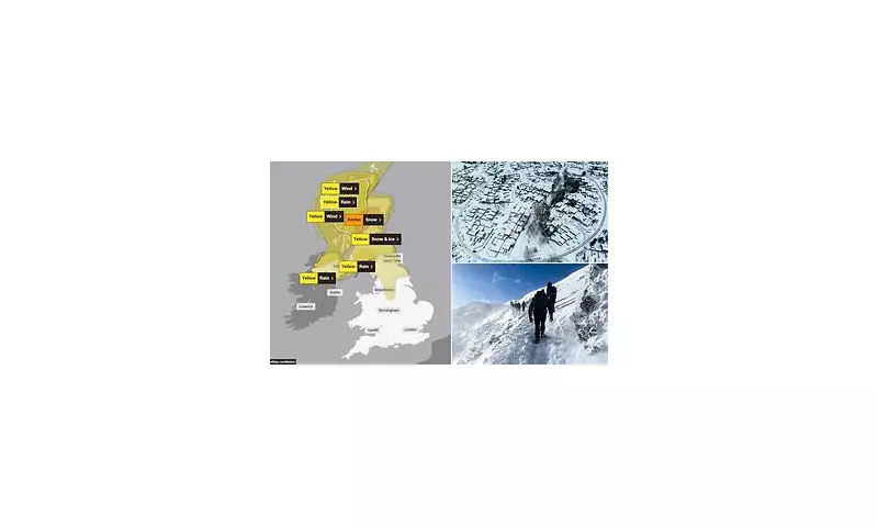
An amber warning for snow and ice will be active from 3am until 2pm on Sunday, covering areas from North East Scotland through Tayside and into Central Scotland. Forecasters have warned the public to expect severe travel disruption, potential power cuts, and dangerous conditions. This alert signifies a heightened risk, where prolonged delays and cancellations are likely, and communities could become cut off.
Beyond the amber zone, a complex web of yellow warnings for snow, wind, and rain blankets much of England, Wales, and Scotland. National Rail has pre-emptively warned passengers to expect widespread disruption to services throughout the weekend. In response to the deteriorating situation, Scottish government officials, police, and local authorities held an emergency meeting on Saturday to coordinate their response.

Snowfall Totals, Power Outages, and Flood Risk
The Met Office predicts a further 2–5cm of snow at low levels, with a staggering 10–20cm possible above 200 metres, and up to 30cm on the highest ground. This follows significant accumulations already recorded, including 27cm at Altnaharra in Sutherland and 15cm at Lake Vyrnwy in Powys.
The storm's impact is already being felt on essential services. At 6am on Saturday, around 28,000 properties were without power in the South West, with nearly 1,700 affected in the West Midlands and 150 in the East Midlands. While power has been restored to all homes in Wales, Downing Street confirmed support is being offered to affected households. Transport Scotland has warned of 'challenging conditions', possible route closures, and the ongoing threat of further power cuts.
Meteorologists have issued a further grave warning: the dangerous combination of melting snow and heavy rain in the coming days could significantly increase the risk of flooding. The heaviest rainfall so far was recorded in Cornwall, with 61.8mm at Colliford Dam.
Public Safety Concerns and Previous Tragedy
Emergency services have expressed serious concern over public behaviour during the extreme conditions. North Wales Police criticised Instagram-loving tourists for 'ridiculous parking' on snow-covered roads in Snowdonia, stating that abandoned vehicles were putting others at risk of serious injury. Officers warned that cars left in dangerous positions could be towed. Despite an avalanche warning from the Llanberis Mountain Rescue Team, brazen hikers were still pictured attempting to climb Snowdon.
The latest warnings follow a tragic incident linked to Storm Goretti. A man in his 50s died in Cornwall after a tree fell onto his caravan amid hurricane-force winds on Thursday night. Cornwall has since been lashed by gusts of up to 100mph.
Met Office meteorologist Dan Stroud stated the weather will remain "unsettled and cold" over the weekend. He explained that Sunday will start dry in the east, but rain already in the west will move eastwards, falling as snow across the north Midlands and areas further north. The day will be windy for all, with coastal gales and the potential for severe gales in the north west later on.


