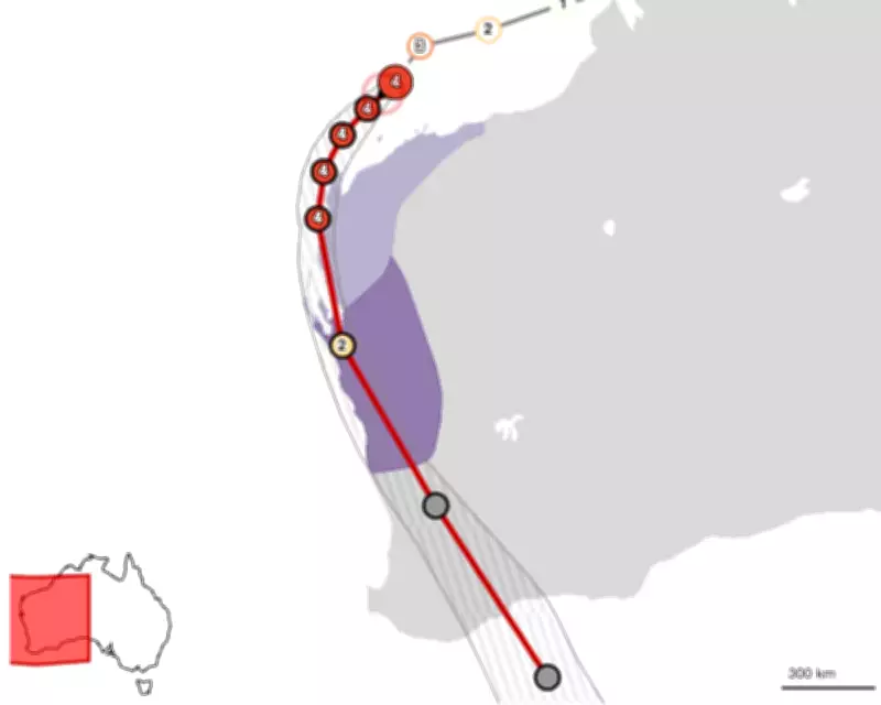
Tropical Cyclone Narelle is on a collision course with Western Australia, with meteorological projections indicating it will make landfall as a severe category 3 system on Friday night. The storm's expected path shows it tracking over Western Australia and nearing the Perth metropolitan area, raising significant concerns for coastal communities and remote towns.
Forecasted Impact and Landfall Details
The Bureau of Meteorology has issued warnings that Cyclone Narelle will intensify to a severe category four storm, with wind gusts potentially reaching up to 275 km/h in Exmouth by Thursday. As it approaches the coast, the system is predicted to downgrade slightly but remain a dangerous category 3 cyclone upon landfall, likely impacting the tourism hub of Denham in Shark Bay.
Historical Context and Unprecedented Journey
This storm system represents a meteorological rarity, as it is poised to become the first in two decades to make landfall across three separate Australian states and territories. Originating in far north Queensland last week, Cyclone Narelle traversed the Northern Territory before continuing its westward trajectory across the Indian Ocean. By the time it nears Perth, the cyclone will have covered an astonishing distance exceeding 5,500 kilometres (approximately 3,400 miles).

Tracking and Monitoring Resources
Residents and authorities can monitor Cyclone Narelle's progression through the live BoM Tropical Cyclone 34U forecast track map, which provides regular updates on the storm's path and intensity. The tracking map below illustrates the expected trajectory towards Perth and Western Australia's coastline, with periodic revisions as new data becomes available.
Emergency services are urging communities along the projected path to prepare for potential destruction, including structural damage, flooding, and power outages. The combination of extreme wind speeds and heavy rainfall could create hazardous conditions across multiple regions.
Regional Implications and Safety Precautions
Remote Western Australian towns are particularly vulnerable to Cyclone Narelle's force, with the storm forecast to pummel these areas with devastating winds before reaching more populated coastal zones. The system's approach towards Perth marks a critical phase, as urban infrastructure and densely populated areas face potential disruption.
Meteorological experts emphasize that while the exact landfall location may shift slightly, the overall threat remains severe. Residents are advised to secure properties, stock emergency supplies, and follow official evacuation orders if issued. The Bureau of Meteorology continues to monitor the cyclone's development closely, with updates expected as the situation evolves towards Friday night's anticipated impact.