Scientists have issued a warning that the world may be heading toward a so-called 'super El Niño', a phenomenon that could drive global temperatures to unprecedented highs. El Niño events are part of a natural cycle known as the El Niño–Southern Oscillation (ENSO), characterized by sustained warm sea surface temperatures across the Pacific Ocean. When this warming exceeds 2°C (3.6°F), it is often informally referred to as a 'super El Niño', though the term is not officially used by scientists.
WMO Warns of Imminent Strong El Niño
The World Meteorological Organisation (WMO) has cautioned that strong or super El Niño conditions could return as early as May or June. Current measurements indicate that sea surface temperatures in the tropical Pacific are rising faster than at any other point this century. Although not yet certain, this trend strongly suggests a powerful El Niño is developing. Wilfran Moufouma Okia, Chief of Climate Prediction at the WMO, stated: 'Climate models are now strongly aligned, and there is high confidence in the onset of El Niño, followed by further intensification in the months that follow. Models indicate that this may be a strong event.'
ENSO Cycle and Current Signs
The ENSO cycle alternates between warm El Niño and cool La Niña phases every two to seven years. During El Niño, warm waters accumulate in the Pacific and spread, raising the Earth's average surface temperature. This heat escapes into the atmosphere, elevating global temperatures for months. While this cycle has persisted for hundreds of thousands of years, current observations in the Pacific suggest that 2026 could experience one of the strongest El Niño patterns ever recorded. Predicting events beyond April is challenging due to the 'spring predictability barrier', but experts are nearly certain that a strong El Niño is approaching.

A spokesperson for the Met Office told the Daily Mail: 'Current forecasts indicate a strong shift in the tropical Pacific later this year, with conditions increasingly supportive of the development of El Niño.' The Met Office's modelling suggests sea surface temperatures could reach 1.5°C (2.7°F) above average, adding that this could be the 'strongest El Niño event so far this century'. Meanwhile, the American National Oceanic and Atmospheric Administration (NOAA) predicts a one-in-four chance of a 'very strong' El Niño with temperature anomalies exceeding 2°C (3.6°F).
Potential for Record-Breaking Heat
Professor Paul Roundy, an atmospheric scientist at the State University of New York at Albany, noted on X that there is 'real potential for the strongest El Niño event in 140 years'. Dr Marc Alessi, a fellow at the Union of Concerned Scientists, wrote in a blog post: 'While the majority of models predict global monthly temperature anomalies will remain below 2C, the fact that there’s a nonzero chance of +2C happening is shocking.' These warnings have raised concerns that 2026 could become one of the hottest years on record, as El Niño triggers extreme weather events globally.
The ENSO cycle is not caused by climate change, and scientists do not yet have conclusive evidence that the greenhouse effect intensifies El Niño. However, a particularly strong El Niño can add extra heat to the atmosphere on top of ongoing global warming. When this occurs, temperatures are very likely to spike to record levels. For instance, scientists believe 2024 was the hottest year on record due to a combination of the greenhouse effect and a strong El Niño. With a super El Niño looming, there is a strong chance that both 2026 and 2027 could set new records.
Global Weather Impacts
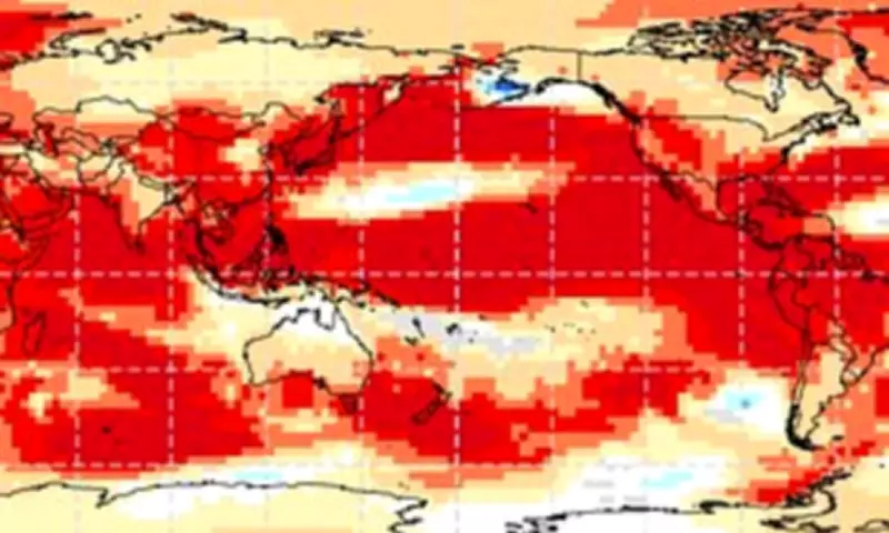
The WMO's predictions for May and June indicate that land surface temperatures will be above average nearly everywhere on Earth, particularly over North America, Central America, the Caribbean, Europe, and North Africa. El Niño also disrupts global weather patterns, typically increasing rainfall and flooding in South America, the United States, the Horn of Africa, and Central Asia, while causing droughts in Australia and Indonesia and raising wildfire risks across Southeast Asia.

For context, the UK's five warmest years on record are: 2025 (10.09°C), 2022 (10.03°C), 2023 (9.97°C), 2014 (9.88°C), and 2024 (9.79°C). El Niño's effects are not evenly distributed, leading to strong temperature increases in Europe and South America, while Southern North America experiences cooler weather and flooding.
What Is the El Niño Phenomenon?
El Niño and La Niña are the warm and cool phases of the El Niño-Southern Oscillation (ENSO), a recurring climate pattern across the tropical Pacific. The cycle shifts irregularly every two to seven years, causing predictable disruptions in temperature, winds, and precipitation. During El Niño, sea surface temperatures in the central and eastern tropical Pacific are above average, rainfall over Indonesia decreases, and easterly winds weaken or reverse. In contrast, La Niña features cooler ocean temperatures, increased rainfall over Indonesia, and stronger easterly winds. Neutral conditions occur when temperatures are close to average.