


Entertainment

Denise Richards Shares Heartfelt Tribute for Daughter Eloise's 15th Birthday
Denise Richards celebrated her daughter Eloise's 15th birthday with a video montage, reflecting on the challenges and joys of raising a child with a rare genetic condition.


Politics

Ray J Hospitalized After Knockout in Influencer MMA Bout, Investigation Launched
Ray J was knocked out in an influencer MMA fight and hospitalized in Las Vegas. He faces heart issues and a potential investigation into match-fixing.


Sports

Learning Jive from Strictly's Shirley Ballas on MSC Virtuosa Cruise
A reporter attempts to learn the jive from Strictly judge Shirley Ballas aboard MSC Virtuosa, enjoying dance classes, shows, and Norwegian ports.


Crime

Josh Jacobs Arrested on Domestic Violence Charges in Wisconsin
Green Bay Packers running back Josh Jacobs faces five domestic abuse charges including strangulation after turning himself in. The team says it's aware and will withhold comment.


Health


Environment
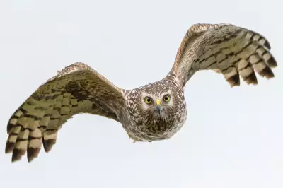
Rare Birds of Prey Killed in Shooting Estate Crimes
Over 920 illegal cases of raptor persecution recorded in a decade, with RSPB calling for licensing of gamebird shoots to protect birds of prey.

Fury Over Glyphosate Spray Plan Near Lake Tahoe
Residents and environmentalists are outraged as the US Forest Service approves glyphosate spraying across 46,000 acres in the Caldor Fire burn scar, including areas near Lake Tahoe.
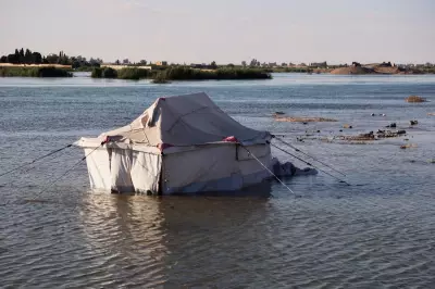
Syria Urges Euphrates Residents to Move Inland as Waters Rise
Authorities in Syria urge residents along the Euphrates River to move inland after rising waters cause flooding in Raqqa and Deir el-Zour, damaging homes and farmland.
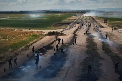
Syria's Freekeh Harvest: Traditional Roasted Green Wheat
Explore photos of the freekeh harvest in Syria's Idlib province, where traditional methods produce roasted green wheat grain for Levantine cuisine.

UK Railways Disrupted as May Temperature Record Hits 35.1C
UK railways face severe disruption as temperatures hit 35.1C, breaking May records. Passengers removed from trains due to heat, with health warnings extended.
Monday Sports Challenge: Football, Cricket & Rugby Questions
Start your week with our Monday sports quiz featuring 100 questions about British football, cricket, and rugby. How well do you know these popular UK sports?
